|
Location
The site of Topraq qala is 27.5km north of Biruniy and 12km north west of Bostan. It lies just south of the escarpment of the eastern end of the
Sultan Uvays Dag.
Ayaz qala lies 20km to the north east.
In fact you can still see Topraq qala from the top of Ayaz qala 1, just as Sergey Tolstov did in 1938 – see below. From the walls of Ayaz qala, point
your binoculars towards the west south-west, beyond the zone of desert immediately ahead. Topraq qala is situated in the agricultural region that lies
just to the left of the Sultan Uvays Dag massif. It stands up high against the surrounding countryside.
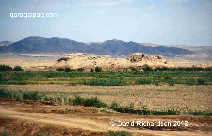
The view of Topraq qala from the south east with the Sultan Uvays Dag as a backdrop.
To get to Topraq qala from Khiva drive through Urgench and cross the Amu Darya pontoon bridge linking Khorezm viloyati with Qaraqalpaqstan.
From the north bank check-point drive north for 2km and then cross the To'rtku'l road. Continue north for a further 1.6km and turn right onto the main
highway for just over 0.5km before turning left. After another 0.5km you cross the main city roundabout and it is then a further 1km to a major
t-junction. Turn right. After 1.5km the road passes the sports stadium and after 1.8km it intersects the main dual carriageway in Biruniy city centre.
Turn right onto the dual carriageway and drive for 1km to the next t-junction. The left turn is the main road to Bostan, about another 21km further on.
On entering the next t-junction, just on the outskirts of Bostan, turn left. This straight road runs directly to the Topraq qala site, which you will
reach after a further 12.8km. A dirt track on the right hand side leads to a parking area beside the mud ruins.
|
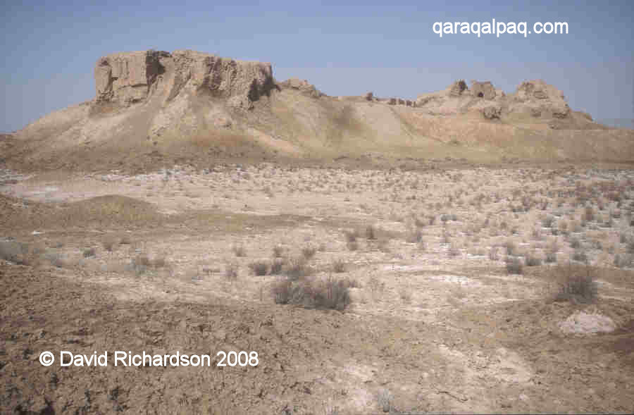
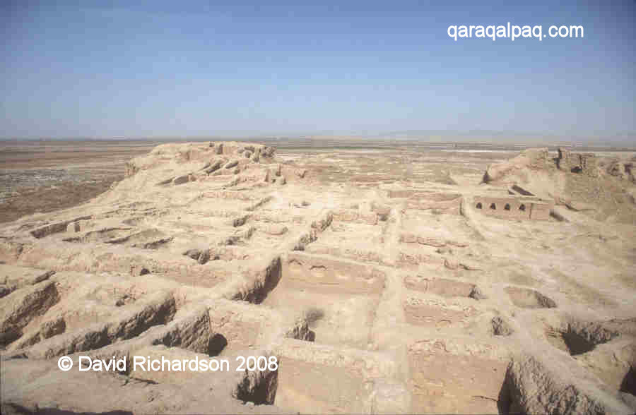
View of Topraq qala from the site entrance showing the elevated High Palace.
Closest to camera is the dominant square fortified tower or keep, located at the north-western corner.
Excavations
In his book "Following the Tracks of Ancient Khorezmian Civilization", Sergey Tolstov recounts the first time he encountered Topraq qala:
"On a clear October evening in 1938 our small prospecting group stood on the walls of the Kushan fortress of Ayaz Qala 1. Along with the familiar
silhouettes of ruins in the south and in the east, far in the west, beyond the smooth plain of takyrs, sand and saline soils, on the horizon
there was the contour of huge ruins with mighty outlines of a three-towered citadel. "What fortress is that?" I asked our guide. "It's Toprak Qala,
there's nothing interesting there" was his laconic answer. Next day our caravan approached the "uninteresting fortress".
The next day Tolstov's group set out for the new site with his small team and their caravan of camels, picking their way through the salt-encrusted
takyrs and solonchaks that peppered the barren desert in between. By the time they managed to reach the ruins it was late in the day,
with the sun already low in the sky. Leaving the guides to unpack the camels and pitch camp, they prepared supper and then set off to explore the ruins.
Tolstov climbed up to explore the remains of the twenty-metre high towers in the north-western corner of the fortress. All around were the remains of
rooms and broken arches. The sun was setting behind the Sultan Uvays Dag and from the southern tower its slanting rays picked out the plan of the
ancient city, with its walls and gates, main street and side alleys.
Tolstov and his team realised that they had discovered a monument of outstanding importance.
They returned in 1940 to survey the site, planning to begin excavations the following year. However the onset of war delayed their return until 1945.
Archaeological work continued at Topraq qala for a further twenty-one seasons.
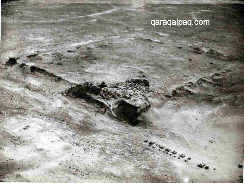
Aerial photograph of the camp of the Khorezm Archaeological Expedition at Topraq qala.
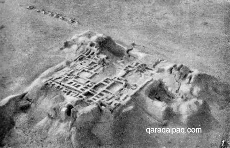
Aerial photograph of excavations at the Topraq qala high palace in 1950.
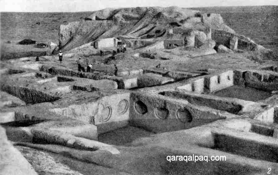
Archaeologists working on the Topraq qala high palace in 1950.
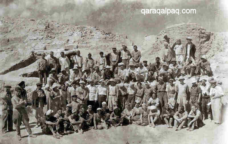
Members of the Topraq qala excavation team.
The overall leaders of the project were Yuri Aleksandrovich Rapoport and Yelena Yevdokimovna Nerazik and their findings were finally published in
Moscow in the form of two monographs in the series "Works of the Khorezm Archaeological-Ethnographical Expedition": Volume 12, "Toprak Kala City",
published in 1981 and Volume 14, "Toprak Kala", published in 1984.
Topraq qala 1
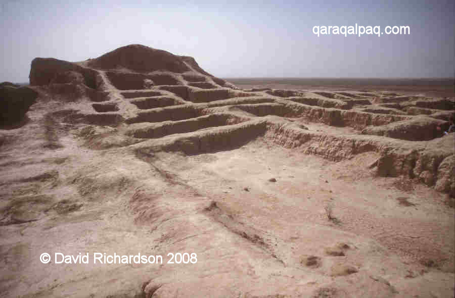
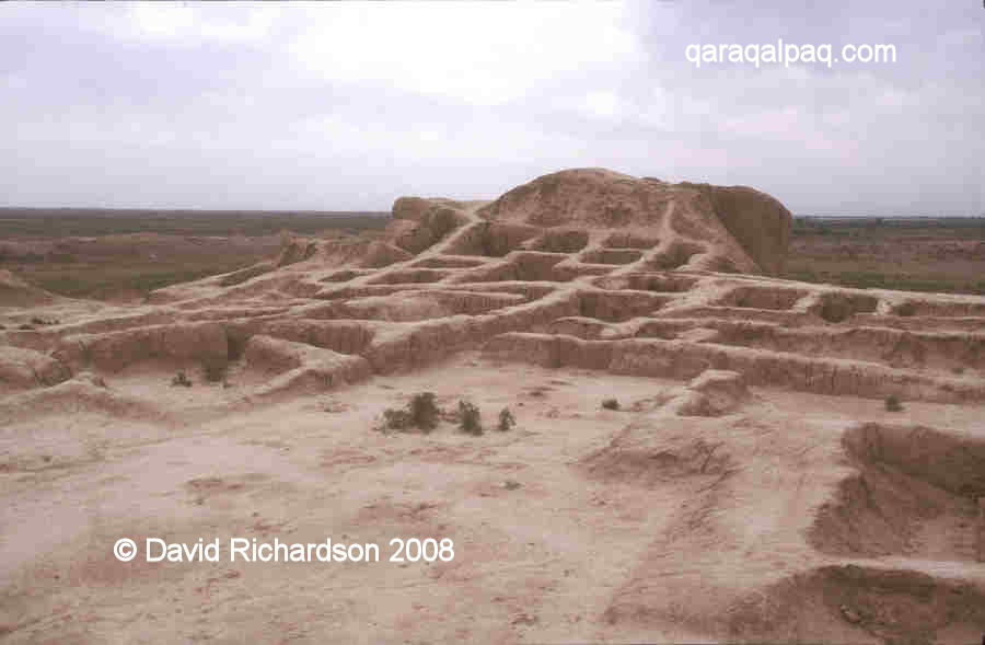
Topraq qala is a local name that means "clay fort", a good description. Of course what we see today are the heavily weathered and well-trodden remains
of a well-excavated site. Sadly the archaeological works were left unprotected and have become badly eroded over the past thirty years.
Professor Yuri Rapoport believed that Topraq qala was a royal city, possibly named after the Khorezmian ruler Artav, whose coins are found at the lowest
level of the site. Today we know that the capital city of Khorezm at that time was probably the site of Axsha-Xan qala, 14km to the south-west of
Topraq qala – a city that may once have been called Darg'ash. It is therefore highly unlikely that Topraq qala was a royal capital and it must have been
a royal summer (or winter) residence.
Construction seems to have commenced in the 1st or possibly the 2nd century AD – it was certainly occupied during the first half of the 3rd century.
The site continued to be used until the 6th century, although the palace was briefly abandoned during the 4th century and was later restored and possibly
used as an administrative centre for the associated city. In the medieval period the site was occupied by squatters until the time of the Mongol invasion
in the early 13th century.
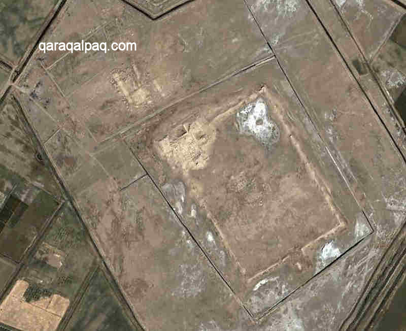
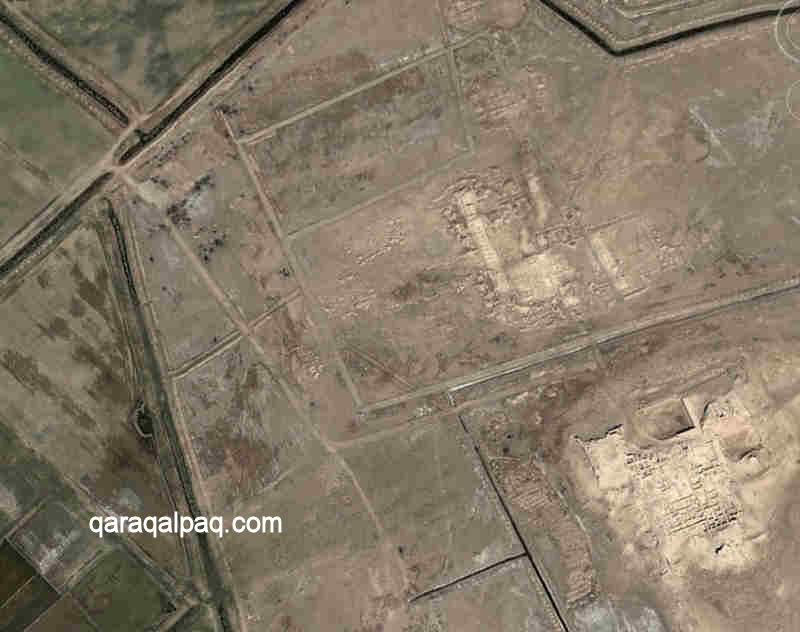
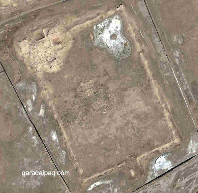
Satellite image of Topraq qala. Image courtesy of Google Earth.
Note the two complexes - the rectangular city containing the royal palace and the palace-temple complex to its north.
Schematic plan of Topraq qala, showing the two parts joined by a causeway.
Image courtesy of Associate Professor Alison Betts, University of Sydney Central Asian Programme.
There are two major components to the site, but most visitors only look at the most obvious one – the south-eastern walled city and its associated palace.
It is this part which has received the most archaeological attention.
The ruins of the city are rectangular, measuring about 500 by 350 metres in size, and are orientated so that the corners face the four cardinal directions.
It was enclosed by imposing walls that even today reach up to 8 or 9 metres in height. These were reinforced with 63 rectangular towers spread out along
the four flanks and larger square towers on the northern, eastern and southern corners. The walls and towers accommodated a lower vaulted passage and an
upper archers' gallery. There was also a wide outer defensive moat. A large rectangular barbican containing a labyrinth entrance was positioned in the
centre of the southern wall.
|
Satellite image of Topraq qala city, showing the high palace in the north-west corner and the southern barbican gate.
Remains of residential buildings can be seen in the centre. Image courtesy or Google Earth.
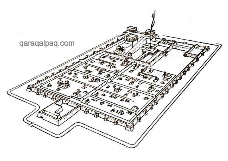
The city was occupied by a large residential area, bisected by a main central thoroughfare leading north from the fortified gate. At right angles to
this thoroughfare were alleyways that divided the city into ten symmetrical blocks, nine residential and one for temples.
Simple sketch of Topraq qala city from Tolstov.
The residential areas contained separate craft centres for the manufacture of bronze, ceramics, textiles and weapons. There was a large water reservoir
in one corner of the city. It was estimated that the city accommodated a population of about 2,500, all of whom would have been engaged in various
functions associated with the royal complex.
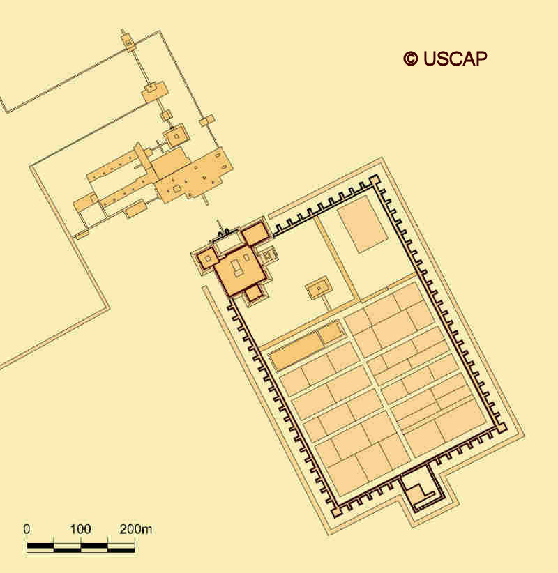
Satellite image of the High Palace. Image courtesy of Google Earth.
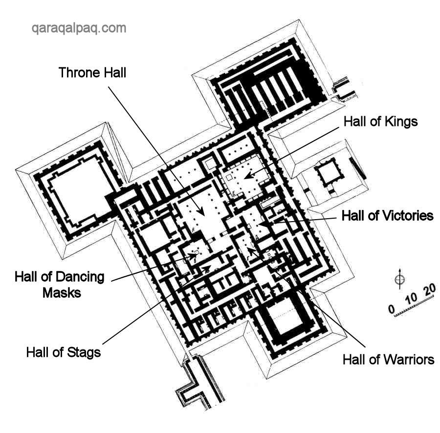
Plan of the High Palace. From Rapoport and Nerazik, 1984.
In the north-western corner, elevated above the rest of the city, stood the citadel or high palace. This was approximately square in shape, measuring
75 by 75 metres, and was defended by substantial fortified walls up to 9 metres in height. It was surrounded by three large rectangular towers – two on
its northern flank and one on its southern flank. The whole complex had all been built on top of a 14-metre high man-made platform in the shape of a
truncated pyramid. The outer walls were ornamented with niches and projections and were painted with alabaster whitewash, giving the whole structure the
appearance of a Mesopotamian ziggurat. The tower on the outermost corner of the citadel seems to have been a triple-floored keep. The palace
contained 102 rooms, some utilitarian but the majority formal and associated with the various aspects of the royal cult. The palace also had its own
fire temple.
|
|
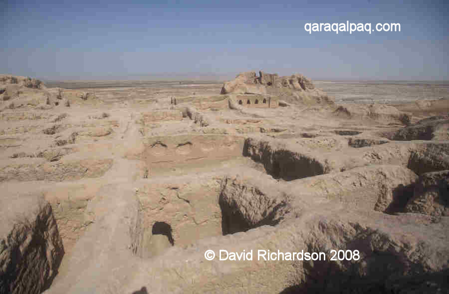
The High Palace, looking north towards the north-west tower (above) and the north-east tower (below).
The High Palace, looking towards the south tower with the Hall of Victories in the right foreground.
The High Palace, looking towards the south tower with the Throne Room in the foreground.
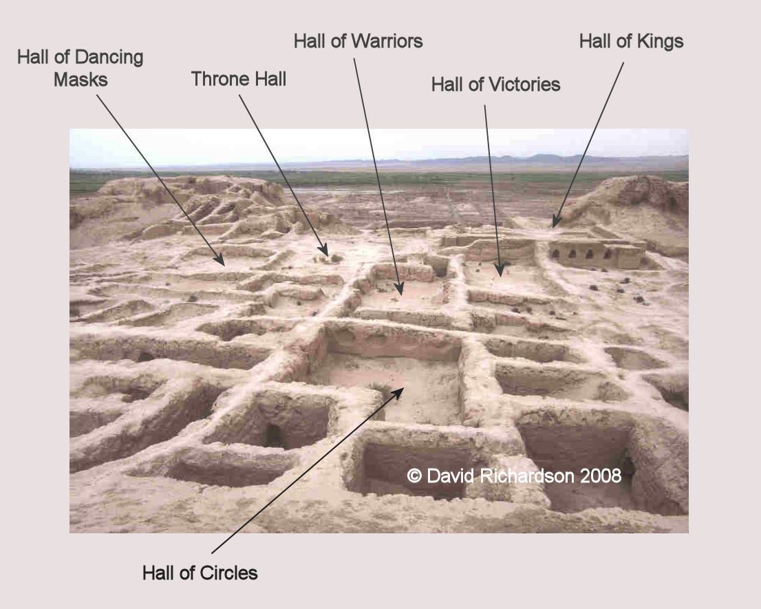
A quick look at the main ceremonial rooms not only gives us some idea of the past opulence of the palace, but provides a glimpse of the rich and formal
lifestyle of its occupants:
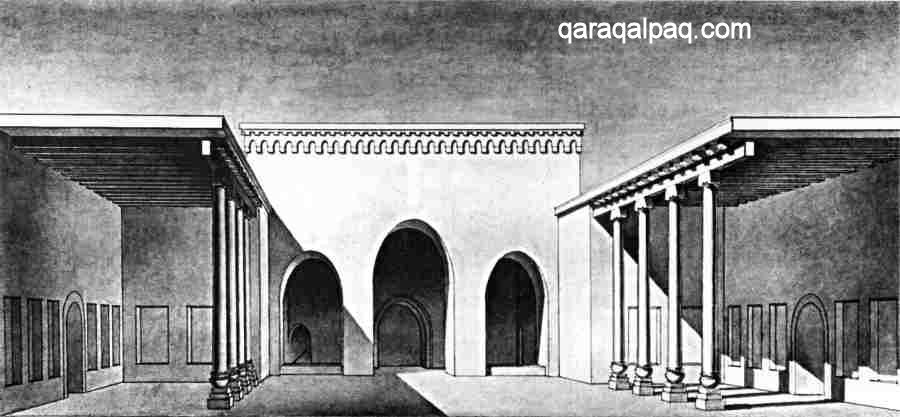
- The Throne Hall was a large courtyard with open ayvans on each side and an ayvan at the far end screened by a portal with three
arches. The central arch was at the exact centre of the palace, and suggests that it might have been the location for the royal throne. Located 30
metres away from the entrance, visitors entering the Hall would have been faced with an impressive sight.
Illustration of the structure of the Throne Hall, from Rapoport and Nerazik.
- The Hall of Dancing Masks was a sanctuary adjacent to the throne room with a central podium for a sacrificial altar. Four columns at the corners
of the podium supported the ceiling. In the centre of each wall was a different panel depicting a full-size dancing couple, surrounded by niches
containing standing figures. The hall has been interpreted as a sanctuary for the principal Goddess of Khorezm, Anahita.
- The Hall of Stags was adorned with bas-relief figures of stags, over the top of which was a frieze depicting griffins.
- The Hall of Warriors had small bas-reliefs of people in armour and life-sized bas-reliefs of men framed by stylized rams' horns, suggesting a
sanctuary celebrating martial victory. The illustration of black men-at-arms with African features might indicate that Dravidian soldiers formed part of the
palace guard.
- The Hall of Victories had repeated bas-reliefs of an enthroned king and two goddesses corresponding to Victory and Fortune.
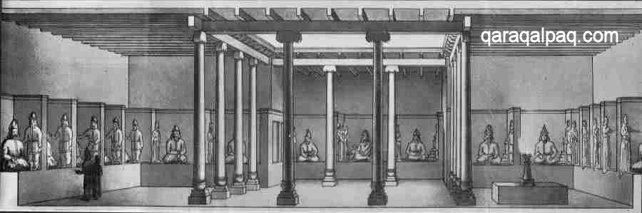
- The huge Hall of Kings was perhaps the most important sanctuary in the palace. It had brick benches along three walls, on top of which were 23 or
24 walled bays, each containing a large seated clay figure. The fourth wall had three bays, the central one being the most important bay of all. The
centre of the room had a columned peristyle at its centre and a fire altar on one side. Tolstov thought the room depicted the royal ancestors - hence
the appellation "Hall of Kings". However the figure in the central position is female, dressed in pink and holding a child's hand and is therefore more
likely to be a goddess. Professor Rapoport has attempted to interpret the contents of the Hall as the entire pantheon of the Gods of Khorezm starting
with Ahura Mazda opposite the sacred flame, allowing one deity for each day of the monthly calendar. Four days of the month were dedicated to Ahura
Mazda, leaving 26 days for 26 "angels of the day". Thus for example, Adur, the deity of fire, was the 9th day, Anahita the Great Goddess was the 10th
day, and Xwar, the deity of the Sun, was the 11th day.
|
Panorama of the Hall of Kings, from Rapoport and Nerazik.
- The Sanctuary contained several different rooms with fire altars and others possibly serving as commemorative shrines.
|
Looking north across the High Palace to the Sultan Uvays Dag.
There was also a library and numerous documents were recovered inscribed on fragments of leather and tablets wood, all written in Aramaic, an ancient
eastern form of Iranian. These and other finds have enabled scholars to partly decypher the pre-Islamic Khorezmian language.
The palace provides an amazing insight into the aristocracy of Khorezm, the lavish surroundings in which they lived, the army of servants and guards
who attended them and the treasure trove of art with which they were surrounded.
Topraq qala 2
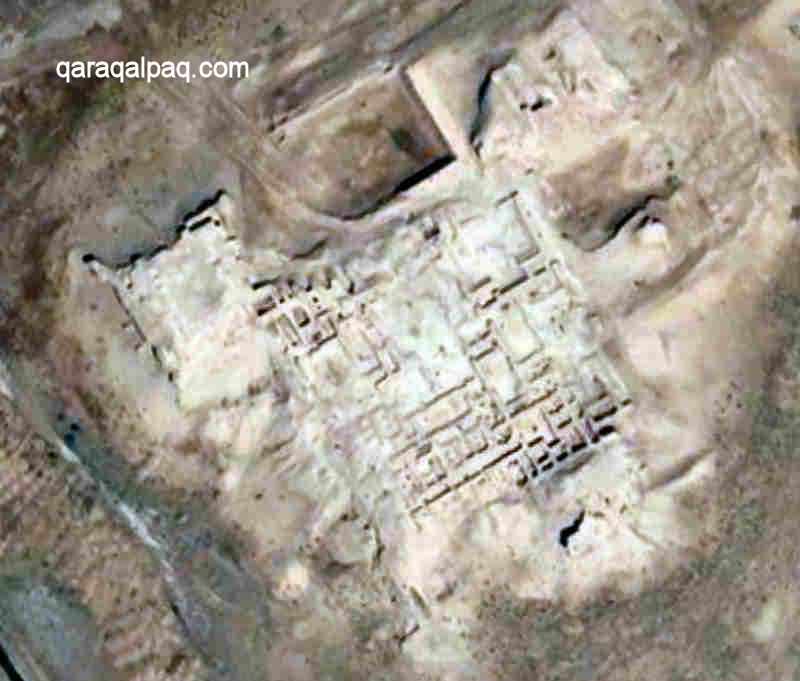
To the north-west of the city and palace was a separate palace-temple complex, with fourteen buildings and ceremonial walkways, some ceremonial, some
religious and some residential apartments, along with ayvans and courtyards for relaxation. The ruins of these buildings lie just under
100 metres north of the high palace. Immediately adjacent was a huge open enclosure, about 1km long and 1¼km wide, surrounded by massive walls,
possibly a stadium for major festivals and equestrian competitions tied in with Saka-Massagetae traditions. Much of this has been ploughed up for
agriculture in recent decades.
Satellite image of the Palace-Temple Complex, just north of the High Palace.
Image courtesy of Google Earth.
A processional way directly linked the high palace to the palace-temple complex.
The existence of two palaces has led to the hypothesis that there were essentially two rulers of Khorezm at that time – one royal and one religious.
That would certainly explain the importance placed on major religious structures throughout the realm.
Google Earth Coordinates
The following reference points (in degrees and digital minutes) will enable you to locate Topraq qala and its component parts on Google Earth:
| | Google Earth Coordinates |
|---|
| Place | Latitude North | Longitude East |
|---|
| Topraq qala City | 41º 55.635 | 60º 49.375 |
| Topraq qala High Palace | 41º 55.715 | 60º 49.250 |
| Palace-Temple Complex | 41º 55.820 | 60º 49.170 |
| | | |
Note that these are not GPS measurements taken on the ground.
Return to top of page
Home Page
|
|