Pil qala and Kath
|
Pil qala and Kath
|
|
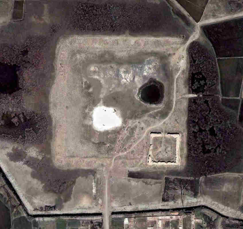
LocationA visit to Pil or Fil qala is really only for those with a serious interest in the history of Khorezm. It is easily accessible, situated behind a residential street on the northern edge of Biruniy and only 2km north north-west of the city centre. It was built on the right bank flood plain of the Amu Darya, which today flows just over 5km to its south-west.
Satellite image of Pil qala. Image courtesy of Google Earth.
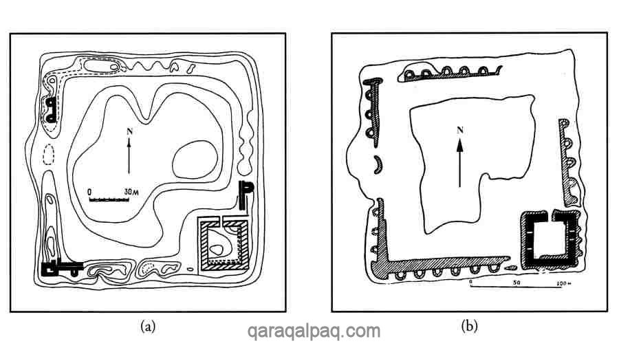
Plans of Pil qala - left by G'ayratdiyin Xojaniyazov, right by Sergey Tolstov in his "Ancient Khorezm" published in 1948.
The History of Medinat al-Fir and KathAlthough the remains of the fortress of Pil qala look uninspiring now, it may have been the power base of the Afrigid dynasty of Khorezmshahs who ruled Khorezm during and up until the close of the second half of the 1st millennium AD. This included the 6th to the 8th century feudal period, the Arab conquest of 712 and the subsequent period of Islamic conversion.Thanks to numerous Islamic geographers and historians, we know that the capital of Khorezm throughout this period was the city of Kath (or Kat or Kyat), a name that seems to derive from the Khorezmian word katha, meaning a walled citadel or fortress � just like the later Turkic word qala. Like many other Central Asian towns of that period, Kath had grown into a city of three parts: the arg, ark or quhandiz, a fortified citadel, which in this case was called al-Fir or al-Fil; the old town or shakhristan; and the new town or rabat. The word rabat comes from rabata, a place for tying-up horses. The rabat was the main commercial and craft centre of a town and often contained the caravanserai. It is possible that al-Fir was the original citadel and medina and that the bigger walled town of Kath grew up around it. It must have been a prosperous city - the 9th century Baghdad historian al-Baladhuri compared it to Samarkand. The first historical account comes from the author Abu Ishaq Ibrahim ibn Muhammed al-Istakhri, who - in the mid-10th century - recorded that the Khorezmian capital of "Kyat" was about a third of a farsakh [a distance that varied from region to region, normally around 6km] in each direction. It had an uninhabited fortress, an old city that had been destroyed by the river, and a newly built city behind it. The prison was near the fortress, the cathedral mosque was situated behind the fortress; and the palace of the Khorezmshah was near the cathedral mosque. A river channel ran through the town, dividing the old quarter from the bazaar. The gates of the city had already been swept away by the river and it was feared that the fortress too would be soon be destroyed since the river had already reached it. Next comes a description from al-Muqaddasi, who was born in Jerusalem in about 945 and published his geography of the Islamic world around 985/6. He never visited Khorezm so must have obtained his rather unflattering description of the town indirectly: "Kyat, which the people call Shahrastan, is riverine, about the size of Nishapur, it lies on the east side of the river. A mosque stands in the midst of the markets, with columns of black stone the height of a man, above which are wooden pillars. The administrative offices are in the centre of the town, there being also a quhandiz which the river has left in ruin. Streams flow through the town, which indeed is magnificent, having scholars, litteratuers, prosperity, agricultural products, commerce. The builders here are skilful, and the like of their reciters of the Qur'an are not to be found in all Iraq. Here is perfection in chanting, excellence in reciting, similarly in appearance and reputation. However, the river is constantly flooding it, so they are all the time backing away from the bank. Kyat is dirtier than Ardabil [a city in Azerbaijan], for here are numerous channels along the streets into which they publicly defecate. They then collect the excrement in pits, to transport it to the arable land in buckets. It is not safe for the stranger to appear abroad until daybreak because of the extent of the excrement; but the natives walk in it and carry it on their feet into the communities. The people have a coarse nature, an ugly disposition; their food is bad, their city vile."The anonymous Hudûd al-Âlam, written in 982/3, described Kath as a major commercial city, trading with the nomadic Oghuz and the Khazars on the Volga, with the Syr Darya (Turkestan), and also Bukhara (Transoxiana): "Kath, the capital of Khwarazm and the Gate of the Ghuz Turkestan. It is the emporium of the Turks, Turkistan, Transoxiana, and the Khazar. It is a resort of merchants. Its king, who is one of the margraves, is called Khwarazmshah. The people are active fighters of the faith and are warlike. The town abounds in wealth."The final account comes from a local man � the scientist Abu Raihan Muhammad al Biruni who was probably born in the birun or external district of the city of Kath in 973 and died in Ghazna [Ghazni in modern Afghanistan] in 1048. In his "Chronology of Ancient Nations", written around 1000, he noted that a king named Afrigh built his castle behind Al-Fir 616 years after Alexander the Great [about 306 AD]: "This Alfir was a fortress on the outskirts of the city of Khwarizm, built of clay and tiles, consisting of three forts, one being built within the other, and all three being of increasing height; and rising above the whole of it were the royal palaces, very much like Ghumdan in Yaman [a fort in San'a in the Yemen]. ... This Alfir was to be seen from the distance of 10 miles and more. It was broken and shattered by the Oxus and swept away piece by piece every year, till the last remains of it had disappeared 1305 years after Alexander [about 994 AD]."Unfortunately there are major doubts that there ever was a King Afrigh � no coinage bearing the name of such a Khorezmshah has ever been found, although there were coins struck in the name of a King Bravik or Fravik during the late 6th and early 7th centuries. It was not only the Amu Darya that led to the eclipse of Kath. In the Amu Darya delta to the north of Kath, a semi-independent federation of nomads had established themselves at Kerder. At the same time a new northern power centre had emerged on the opposite left bank. Named Khamjird, it was ruled by its own King from its own rapidly growing capital city of Gurganj. After centuries of animosity, the King of Khamjird, Amir Mamun, finally invaded Kath in 995, deposing the Khorezmshah Abdullah Muhammad and uniting the whole of Khorezm under his control. The capital of Khorezm transferred from Kath to Gurganj, the latter becoming the capital of the region for the next four centuries. Later, after the Mongol invasion, Gurganj prospered again as a main commercial hub of the Golden Horde. Kath and the right bank territories of Khorezm became a backwater in the ulus of Chagatay. When ibn Battuta travelled from Gurganj to Bukhara in the 1330s he found that al-Kat (Kath) was the only settled place on the right bank. He described it as "small and pretty". Some forty years later it was laid waste again by Timur. The Englishman Anthony Jenkinson passed through Kath in 1558 and described it as a castle ruled by a Sultan Saramet (possibly Sulayman, a cousin of the ruler Dost Khan). Anusha Khan, who ruled Khorezm from 1663 to 1685, decided to build a new walled town at Kath, although when the Pazukhin brothers visited the town a little later they found it virtually deserted, most of the residents having taken their livestock off to the summer pastures. Pil QalaGiven these broadly consistent historical references archaeologists from the Khorezm Archaeological Expedition, including Tolstov, assumed that al-Fir must have been completely destroyed, the fortress undermined by the collapsing riverbank in the same way that the Russian capital of Petro-Alexandrovsk was obliterated by the Amu Darya in the 1930s. However flooding does not necessarily imply complete destruction. During the last decade it has become increasingly clear that the site of Pil qala, or Fil Kala, corresponds to the ancient citadel of al-Fir or al-Fil. It is just under 3 km from the ruins of the later city of Kath.
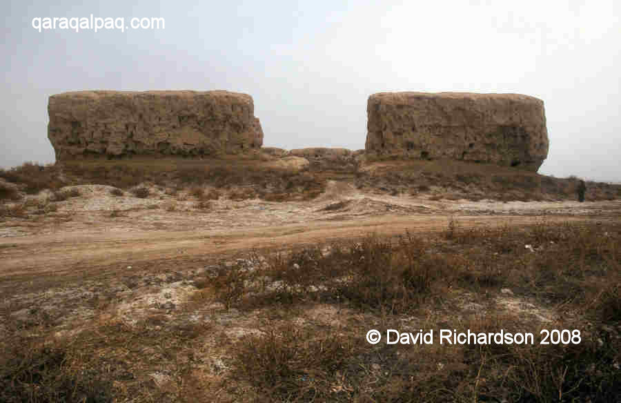
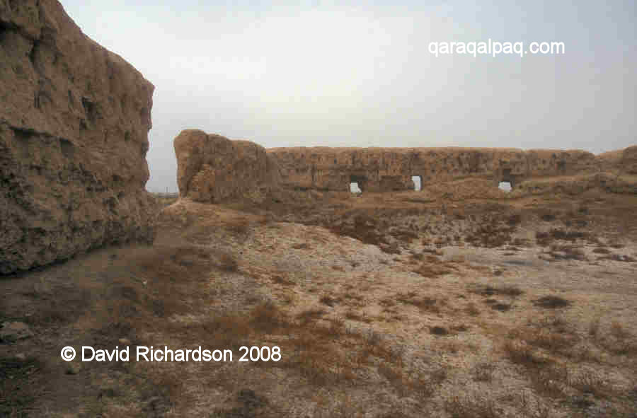
Front elevation of Pil qala citadel.
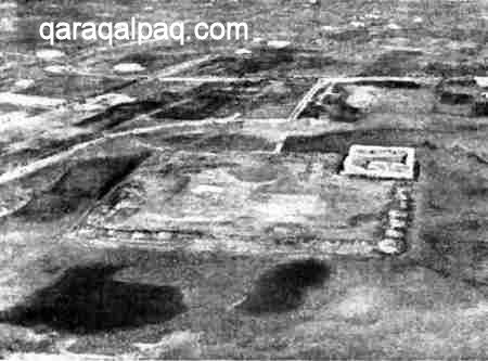
Aerial photograph of Pil qala taken by the Khorezm Archaeological Expedition.
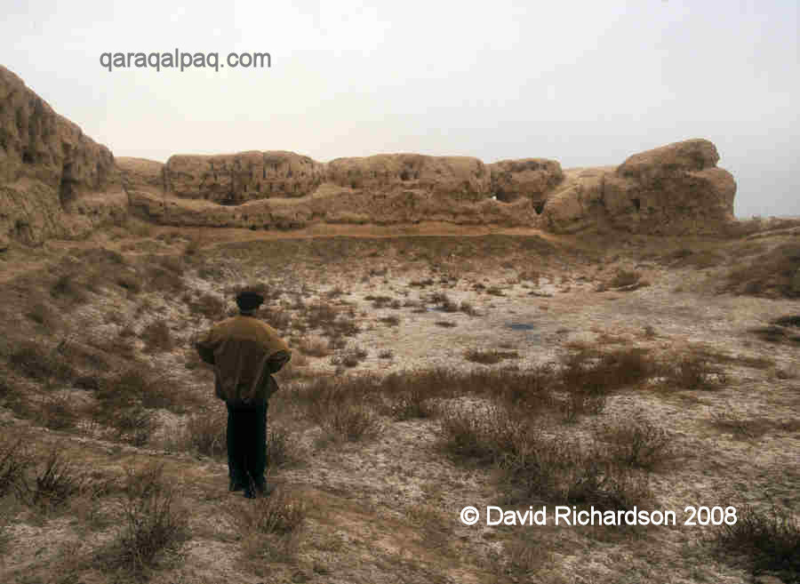
Panorama of the interior of Pil qala.
Interior of Pil qala.
The Ruins of KathThe medieval ruins of Kath lie on the southern outskirts of Biruniy, just under 3km south of Pil qala. Little remains today apart from some short sections of the city wall.
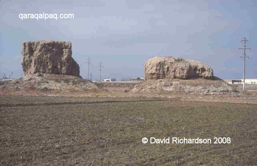
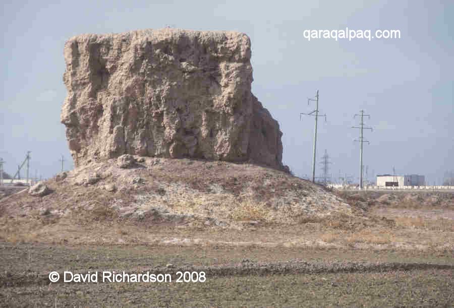
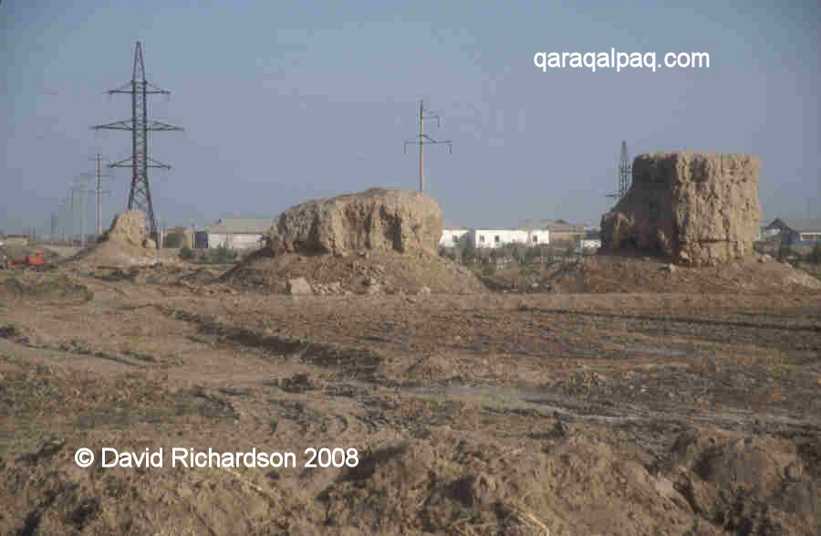
Ruins of the walls of Kath in 2003.
Ruins of the walls of Kath during the creation of the park in 2004.
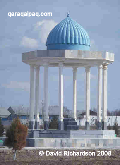
Monument to al-Biruni.
Google Earth CoordinatesThe following reference point (in degrees and digital minutes) will enable you to locate Pil qala and Kath on Google Earth.
Note that these are not GPS measurements taken on the ground. |
||||||||||||||||||||||||||||||||||||||||||||||||
 |
This page was first published on 3 September 2008. It was last updated on 31 January 2012. © David and Sue Richardson 2005 - 2018. Unless stated otherwise, all of the material on this website is the copyright of David and Sue Richardson. |