|
Location
Qalmaq or Qalmıq qala is situated on the elevated plateau of Qırantaw, whose western cliffs overlook the right bank of the Amu Darya some 40km
downstream from No'kis. It is a quiet and beautiful area, which falls within the tuman of No'kis.
Qrantaw is 31km north-west of No'kis as the crow flies but it takes 39km to drive there by road. From the Central Bazaar drive north and take the
first left turn, which crosses the bridge over the Qızketken Canal. Take the first right after the mosque. Drive straight for 1.8km until
you reach the t-junction at the end of the road and then turn right.
This new road first heads north and passes through the town of Aqman'g'ıt before heading off in a more westerly direction. After 20km from the
t-junction the road forks in two directions. Stay left avoiding the right turn. After 26km from the t-junction the road bends to the right. After a
few zigzags and a further 6km it crosses two canals spaced just ½km apart from each other. After just one further kilometre it arrives at the
main street of the old leprosy hospital. At the t-junction turn right and drive up onto the sandy plateau. Qalmaq qala lies about 0.6km north-west
of the entrance while the Amu Darya lies straight ahead.
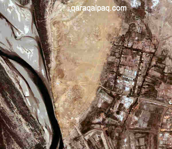
The location of Qalmaq qala and the Qırantaw plateau.
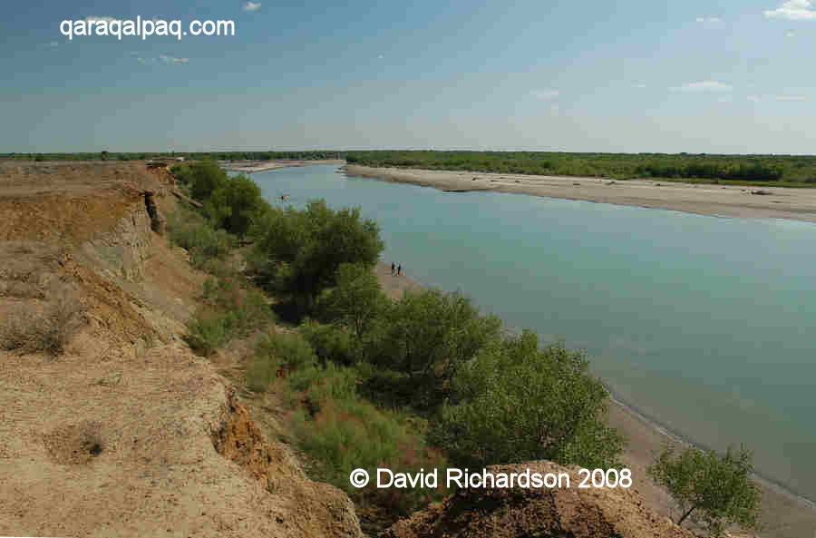
The river bank at Qırantaw is a fine place on a hot day for a picnic or for a swim. However beware of the danger of fishing nets stretched out below
the water line.
Excavation
The cemetery of Qalmaq qala was first studied in 1958 by the young Vadim Yagodin and his colleague A. V. Gudkovoy from the Department of Archaeology
at the Qaraqalpaq Branch of the Academy of Sciences of the Republic of Uzbekistan in No'kis. Their overall objective was to survey the archaeological
sites along the right bank of the Amu Darya. In 1960 the No'kis-based ethnographer Xojamet Esbergenov examined the rectangular paqsa burial
enclosures at Qalmaq qala in more detail and concluded that they were some of the earliest Qaraqalpaq monuments in the Khorezm region.
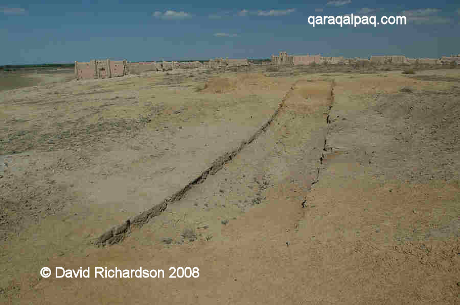
The remains of a trench at the Qalmaq qala site.
The site was generally forgotten until 2000, when G'ayratdiyin Xojaniyazov, N. Yusupov, and Shamil Amirov from the local Qaraqalpaq branch of the Academy
of Sciences examined the graves in detail to study the funeral cult of the Qaraqalpaqs between the 17th and the 19th century. G'ayratdiyin Xojaniyazov
published more results in 2005.
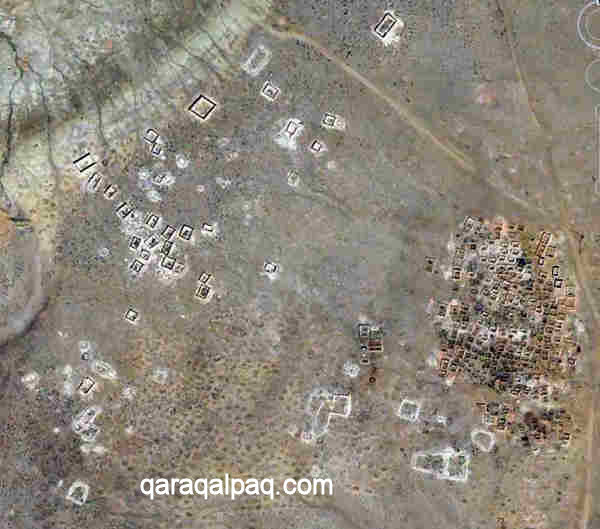
The rectangular burial enclosures of Qalmaq qala on the left, with simple graves on the right.
A scientific monograph on the site is expected to be published shortly.
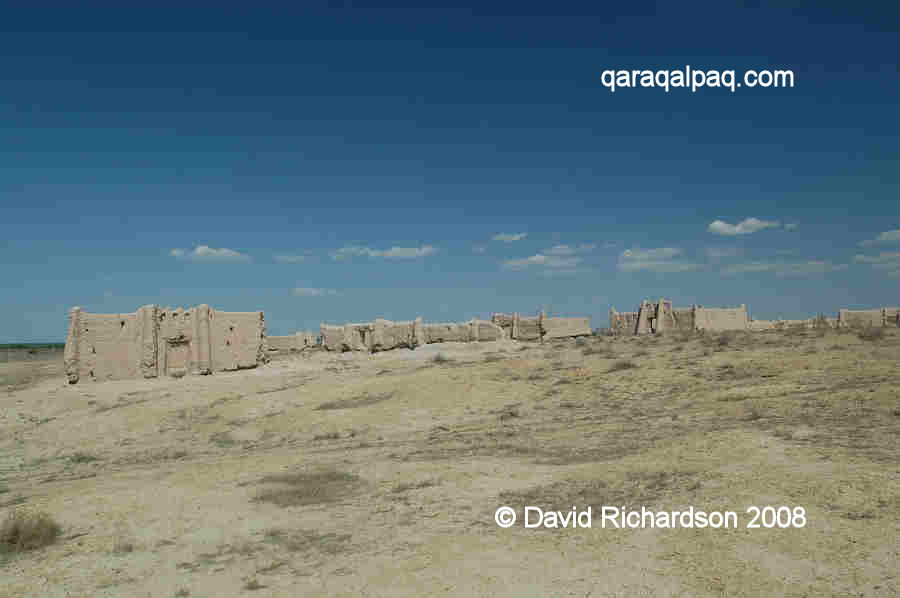
Qalmaq qala
The sandy elevation of Qırantaw has been used as a necropolis by local people for more than two millennia. Today there are three main burial regions
on the plateau – in the south, in the middle, and in the north. Many of the graves are simple earthen mounds covered with a conical layer of brushwood.
However the most interesting part of the necropolis is in the central region of the Qırantaw plateau where there are many burial structures made from
paqsa or compacted clay. This part of the cemetery is known as Qalmaq qala.
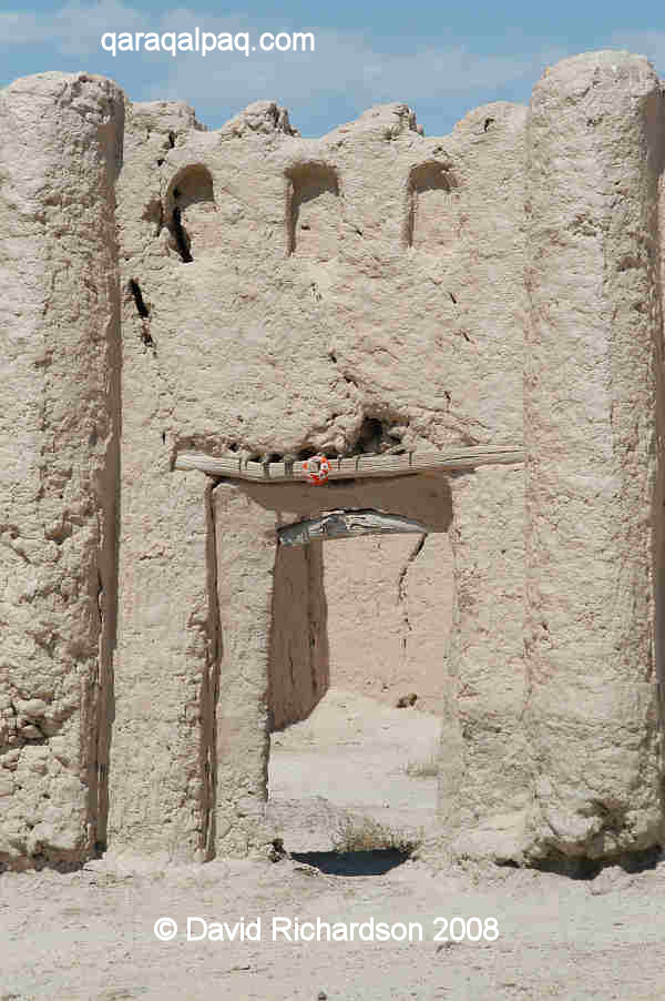
View of Qalmaq qala.
The literal meaning of Qalmaq qala is the "settlement or town of the Qalmaqs" [Kalmuks]. The latter were a western confederation of the Mongol Oirat tribe, who
migrated from the upper Irtysh River to the lower Volga in the early 17th century. Qalmaq was presumably a name given to the Oirats by their Turkic
neighbours - it originates from the Turkic word qal meaning "to remain".
However Qalmaq qala is neither a qala nor is it Qalmaq. It is a Qaraqalpaq cemetery or a'wılie – in fact it used to be called
Qalmaq a'wılie. Nobody understands why it was given the name Qalmaq although there are various theories, one being that it might have
been named after the Qalmaq clan of the Qaraqalpaq Qoldawlı tribe. Although the monument is known as Qalmaq qala in Qaraqalpaq it is generally
referred to as Kalmak Kala, the form of the Russian transliteration. Qalmaq qala contains around 80 separate Qaraqalpaq burial enclosures.
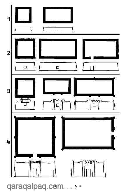
Four basic types of burial enclosure.
Archaeologists have identified four basic types of Qaraqalpaq funeral monument, ranging from simple low-walled enclosures to structures that look like
small dwellings, with high castellated walls, doorways, windows and corner turrets. The latter are like small versions of the traditional Qaraqalpaq
and Khivan Uzbek fortified farmstead, known locally as a ha'wli. Some are even decorated with vertical lines and patterns. The funeral monuments are arranged
in a random higgledy-piggledy fashion, some separated from each other by just a narrow corridor. Each contains one or more simple burial sites.
Although the Qaraqalpaqs buried their dead according to normal Islamic traditions, their funeral monuments were clearly culturally distinct. Many
similar monuments have been identified in other parts of the lower Amu Darya and the Aral delta.
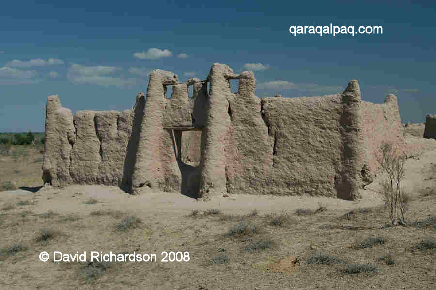
Two examples of Qaraqalpaq ha'wli-like burial enclosures.
The 17th century dating of some of these funeral monuments shows that the Qaraqalpaqs were already widely dispersed at this early time. The very first
historical mention of the Qaraqalpaqs was in the late 16th century and related to a region not far from the modern city of Turkestan on the Syr Darya,
750km east of Qırantaw.
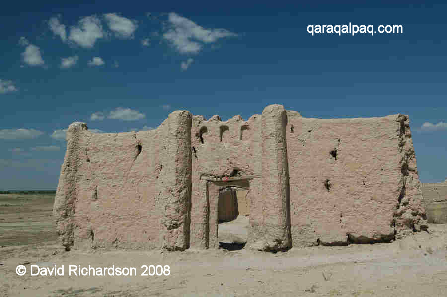
Entrance to a burial enclosure with turrets and other decorative features.
In addition to the funeral monuments, there are also the remains of two small mosques nearby, both built from paqsa clay – the Bektemir Ishan
mosque and the Bakhauddin Ishan mosque.
Archaeologists from No'kis have used the necropolis at Qırantaw to analyse the trends in burial practice and frequency over the past millennium. One
important finding is that the cemetery fell into disuse for most of the 15th and the 16th centuries. This coincides with a major man-made ecological
crisis across the Aral region. For maybe five centuries prior to Timur's conquest of Khorezm (in 1388), the Amu Darya had been dammed close to Kunya
Urgench. This prevented the river from flowing naturally into the Sarykamysh Lake, forcing it to flow northward through the Aral delta into the Aral Sea.
Timur's destruction of the dam changed the course of the river. The Amu Darya ceased to flow into the Aral Sea, leading to a massive fall in its level,
precipitating an environmental crisis of similar proportions to that being experienced today. The Amu Darya delta dried out, resulting in its almost
complete depopulation. Its nomadic occupants moved with their livestock to neighbouring regions such as Devkesken and the lower Syr Darya. The delta
was only repopulated in the early 17th century after the Amu Darya had naturally changed its course to the north.
|
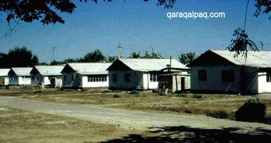
The Qırantaw Leprosy Hospital.
The neighbouring leprosy hospital still holds about 100 residents. It was almost medieval in its appearance until 2004 when the present modern buildings
were constructed.
The cliff edge at Qırantaw overlooking the Amu Darya.
Google Earth Coordinates
The following reference point (in degrees and digital minutes) will enable you to locate Qırantaw and Qalmaq qala on Google Earth:
| | Google Earth Coordinates |
|---|
| Place | Latitude North | Longitude East |
|---|
| Qalmaq qala | 42º 38.660 | 59º 19.290 |
| Qırantaw entrance | 42º 38.345 | 59º 19.460 |
| | | |
Note that these are not GPS measurements taken on the ground.
Return to top of page
Home Page
|