|
Location
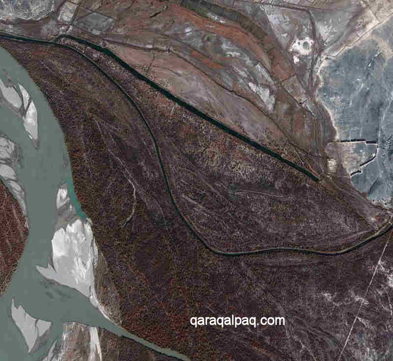
Janpıq qala is situated on the border line between the flood plain of the Amu Darya and the western foothills of the Sultan Uvays Dag. It is
about 2.25km from the right bank of the river and 6km west of the main escarpment of the mountains. The extensive Badai Tugai Nature Reserve lies just
to its south on the other side of the Ko'k Darya. The monument falls just within the Qarao'zek tuman of Qaraqalpaqstan.
The location of Janpıq qala at the foot of the Sultan Uvays Dag.
Image courtesy of Google Earth.
Only 51km from Biruniy as the crow flies, it takes 77km to get there by road. It is a further 94km by road to No'kis.
Janpıq qala lies just over 7km to the south-east of Gyaur qala and is reached by the same route. To reach the site from Biruniy, leave the city
on the A380 heading for No'kis. The road turns towards the north after leaving the Biruniy urban area, heading for the mountains. After 34km, close
to the mountains, the direction of the road turns towards the east and after 50.5km it reaches the left turn for the Badai Tugai Reserve.
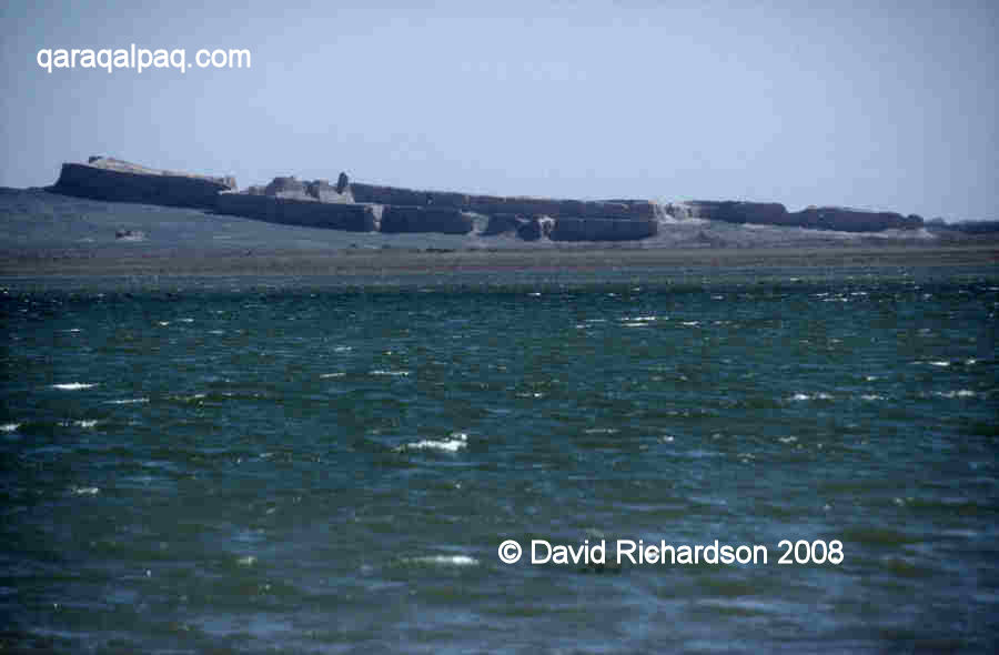
The sloping site of Janpıq qala from the western shore of the lake.
From this point, the road continues straight for a further 4.25km and then bends right, heading due north. After 12.3km from the Badai Tugai junction
there is a metalled side road on the left. Continue along this side road avoiding any further side turns. Just over 7km from the A380 there is a
rough road on the left that runs along the western side of a large shallow lake. You can see Janpıq qala in the distance. Some 3.6km down this
road a sandy track forks off to the right. 2.5km further on you reach the walls of the qala.
In dry weather it is possible to reach the site in a normal saloon car.
Excavations
Sergey Tolstov and his Khorezm Archaeological Expedition ignored Janpıq qala in favour of much earlier sites. Work at Janpıq qala was
initiated by archaeologists from the local Academy of Sciences in No'kis and was conducted in the 1970s and 1980s. The results were published in a
sequence of articles, including by Manılov and Khodzhayov in 1972, Kdyrniyazov in 1979 and Oktyabr Dospanov in 1992.
In 1986 a number of medieval woven textile fragments were recovered from the site, including fine cottons, coarse cottons, coloured woollens and heavy
floor coverings.
Janpıq qala
The site is known as Janpıq qala in Qaraqalpaq, spoken and spelt with a dotless i. It is pronounced "Janpuq qala". The site is generally
referred to as Dzhanpik Kala by the archaeological fraternity, which is the transliteration of its name in Russian. Unfortunately the Russian language
lacks sufficient letters to represent the name correctly. It also goes by various similar sounding names such as Djanpik, Janpyk, Janpyq and Jampik.
In Qaraqalpaq janı means side or flank, so its appellation clearly relates to its position on the sloping side of the foothill.
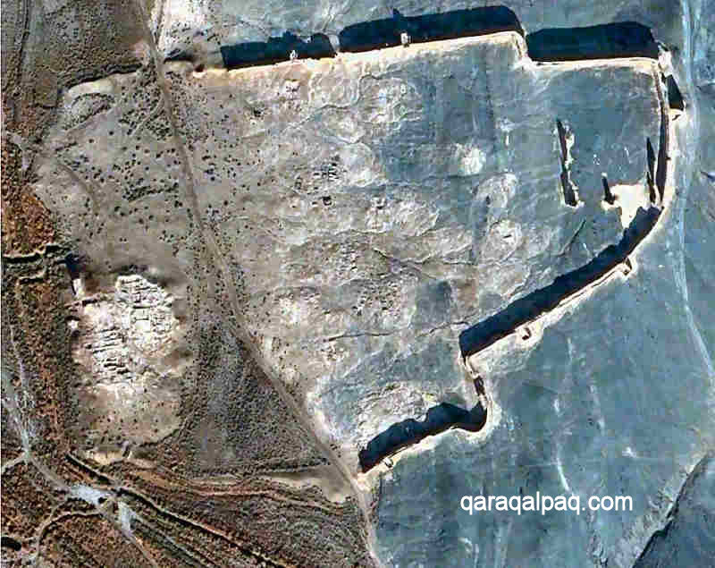
Aerial view of Janpıq qala. Note the remains of the eastern citadel and of dwellings
in the central and western parts of the qala. Image courtesy of Google Earth.
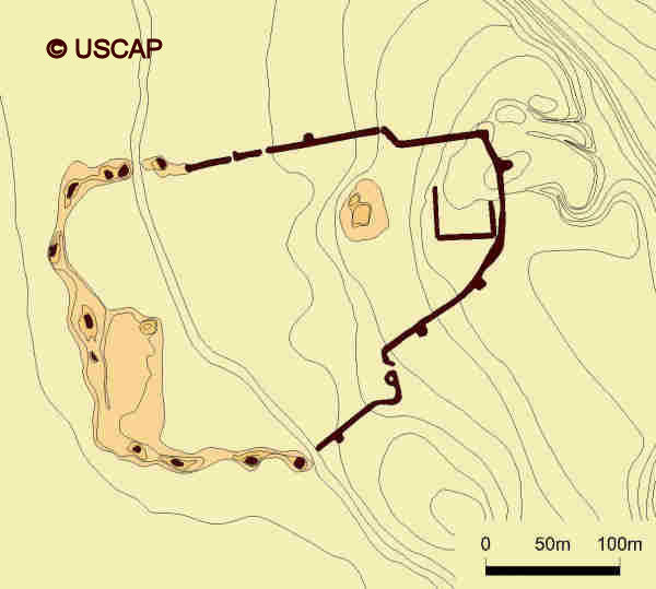
Schematic plan of Janpıq qala.
Image courtesy of Associate Professor Alison Betts, University of Sydney Central Asian Programme.
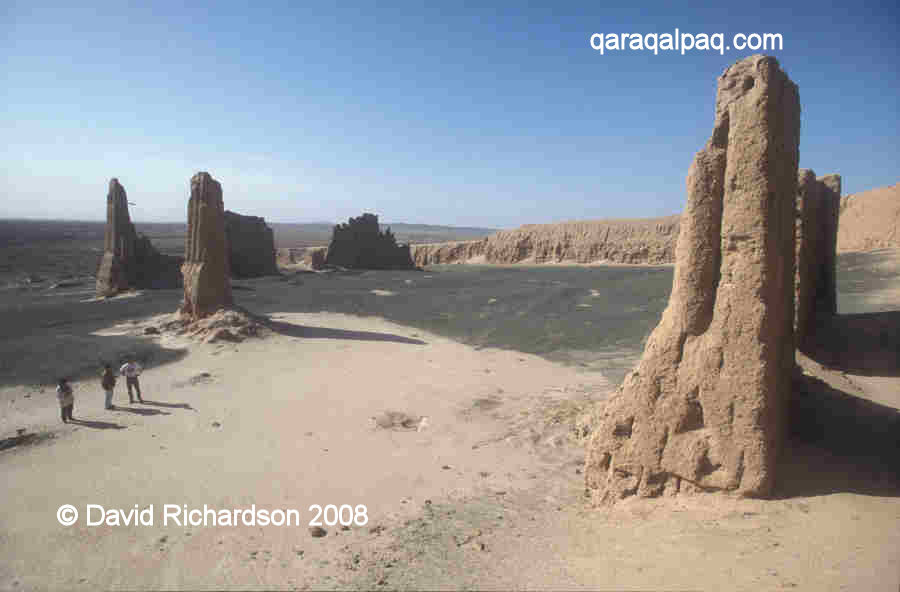
The site is surrounded by defensive walls made from blocks of paqsa or compacted clay. They still stand up to 9 metres high in places. They
extend by about 420 metres from east to west and just under 300 metres from north to south. They give the site an irregular shape which has not been
dictated by the local topography. With the exception of the generally straight north facing wall the boundaries are curved and irregular. There are
no embrasures within the sides of the walls. They were defended by means of an open-air gallery along the top of the wall protected by a raised
castellated outer edge that reached up to chest height. The gallery was reached by steps built into the inner face of the walls.
The lower western sections of the walls facing the Amu Darya have been badly eroded, presumably because of flood damage. Today only five rectangular
towers survive, spaced roughly 100 metres apart. Three of these are located on the south-eastern flank. Only one of the towers contained an internal
room. Presumably there were more towers surrounding the eroded western sections of the wall.
|
The interior of Janpıq qala from the top of the eastern wall.
There are two surviving gates, one on the southern side located at the point where the wall loops out to the south, and the other on the northern wall.
The latter leads out towards the town cemetery about 300 metres to the north. It seems likely that there should have been a western gate leading down
to a wharf on the river bank.
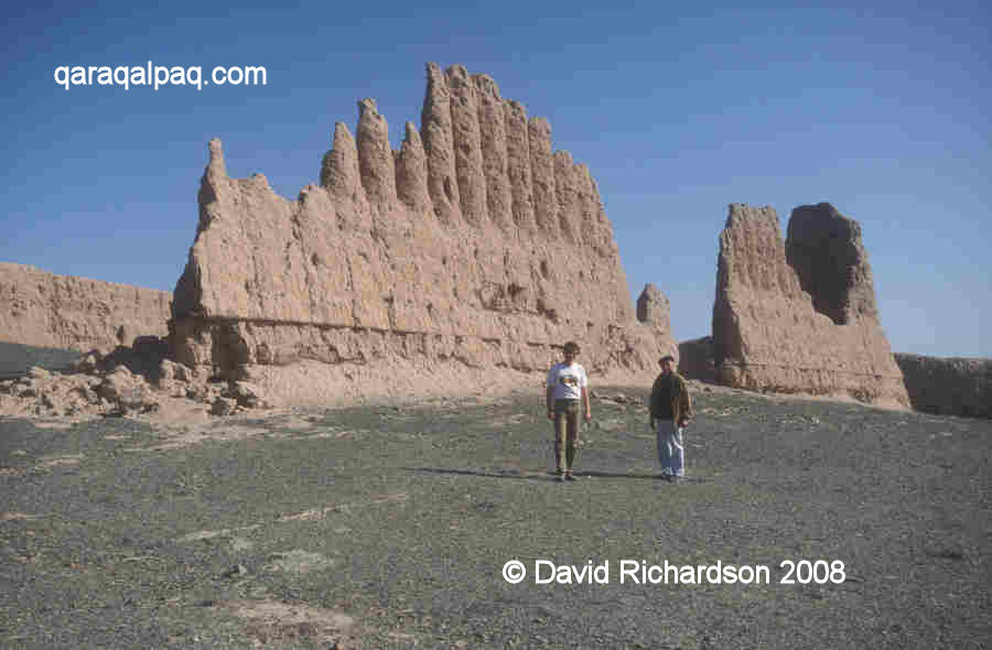
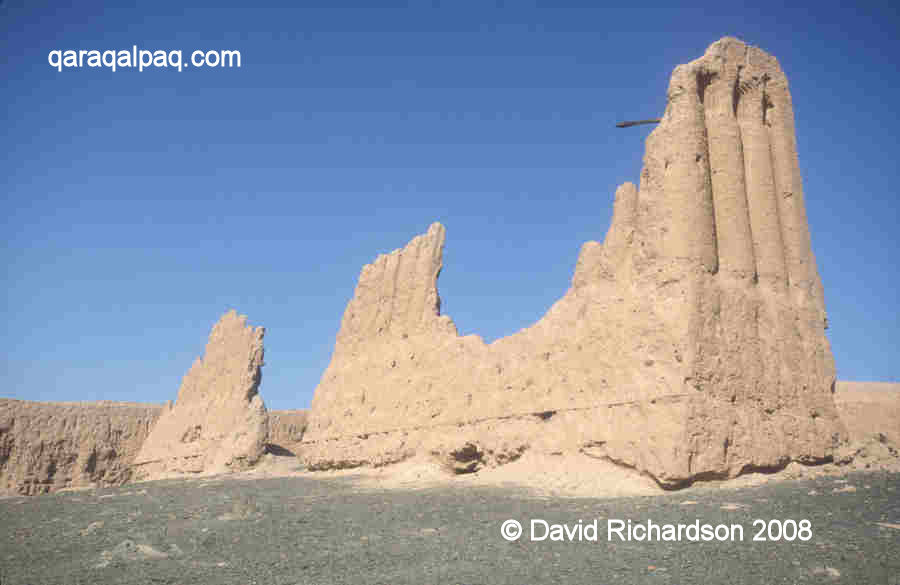
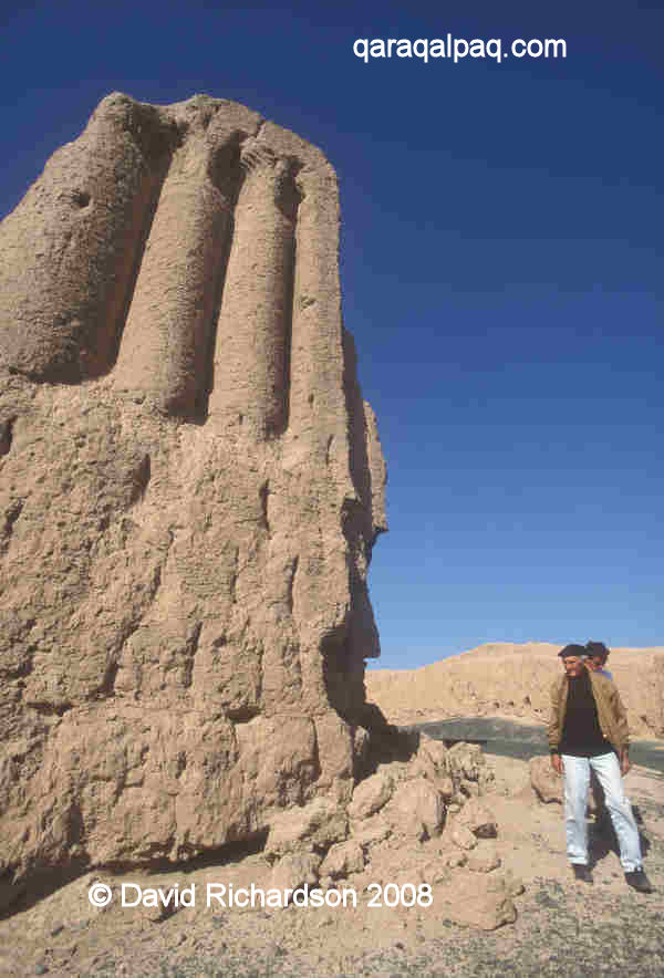
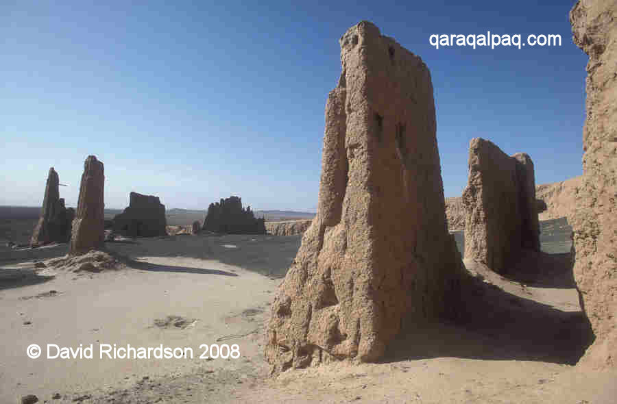
The main surviving internal feature lies at the upper eastern end of the enclosure and consists of the ruined outer walls of a square-shaped citadel or
fortified palace, still standing in some sections up to 12 metres high. The upper portions of the outer walls were decorated with vertical half-round
columns, similar to those found at the 12th century Gyaur qala citadel at Mizdahkan. The citadel was constructed with a layer of reeds in the lower
sections of its walls to prevent damage from salinization.
The sloping and crenellated walls of the eastern citadel.
Note the line of the reed barrier in the lower part of the walls.
Excavations at Janpıq qala identified that it had been built on the site of a much older settlement dating back to the period between the 4th
century BC and the 1st century AD. However the ruins that we see today date from the medieval period. The town was initially built in the 9th or
the 10th century, a time of stability when Khorezm was becoming a wealthy commercial centre. It was conquered by the Mongols in 1221 and there are
signs of a breach in the southern wall dating from this time, which was later repaired. If the local governor had refused to surrender its
populace may have suffered from the usual brutal Mongol response. Even so, the town must have quickly revived to become a thriving centre of
production and trade during the time of the Golden Horde. During this latter period a settlement developed around the outer perimeter of the town
walls. The town seems to have been abandoned at the end of the 14th century, presumably as a result of Timur's devastating campaign to destroy Khorezm
in 1388.
|
Another view of the imposing citadel at the upper eastern end of Janpıq qala.
In addition to its residential area, the town of Janpıq qala contained a district divided up into quarters, each specialising in different
crafts - glass making, weaving, blacksmithing, pottery making and stone carving. These quarters existed from the 10th century to the end of the 14th
century. The town was even equipped with ceramic water pipes and drainage systems.
Dwarfed by the decorated walls of the citadel or fortified palace.
Professor Vadim Yagodin at Janpıq qala in 2002.
The archaeological excavations uncovered a rich selection of finds, some of which can be seen today in the Savitsky Museum in No'kis. These include
ceramics, glassware, metal ware (including bronze discs from China), stone ware, knitting hooks, a net making tool, glass catheters for infants and a
considerable amount of jewellery, including locally made bronze adornments, bone beads and cowry shell necklaces. Silver and copper coins from the
Golden Horde period included those minted under the authority of Janibeg Khan (1340-1357). Some of these artefacts indicate that Janpıq qala
must have been an important port on the Amu Darya, with goods arriving from as far away as China, India, Egypt, the Baltic, the northern Black Sea and
the Volga.
It was during the time of the Golden Horde that a system of communication beacons was established throughout Khorezm. A square-shaped signal tower
that was part of this network is located just a few kilometres north of Janpıq qala.
Google Earth Coordinates
The following reference point (in degrees and digital minutes) will enable you to locate Janpıq qala on Google Earth:
| | Google Earth Coordinates |
|---|
| Place | Latitude North | Longitude East |
|---|
| Janpıq qala | 42º 1.605 | 60º 19.590 |
| | | |
Note that these are not GPS measurements taken on the ground.
Return to top of page
Home Page
|