|
Location
It takes roughly an hour to drive from Khiva to Biruniy and a further hour to get to Ayaz qala via Bostan.
However if you are making a round trip it is better to visit Topraq qala first. It's then just 20km from Topraq qala to Ayaz qala as the crow flies,
although it takes about 32km by road. Leave on the main road running in front of Topraq qala in a south-east direction. After 10.5km, just as the
main road bends to the right, take a left side road which crosses a small canal. After a while the road heads in a straight north-easterly direction
running parallel to a narrow canal on its left side. 15km from the turn the road bends towards the north. After a further 4.2km you cross another
canal and continue for a further 1km. As the road bends to the right, you continue straight ahead on a rough mud track with good views of the sites
of Ayaz qala 1 and 2 ahead. After another 1.2km up the escarpment you arrive at the Ayaz qala yurt camp.
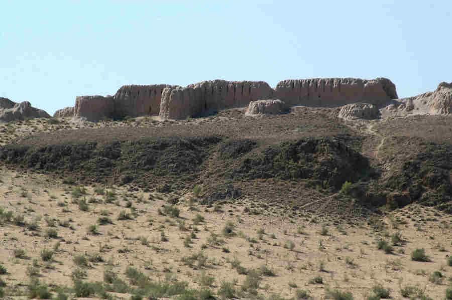
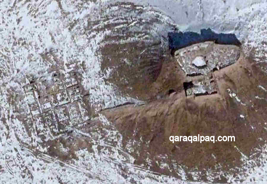
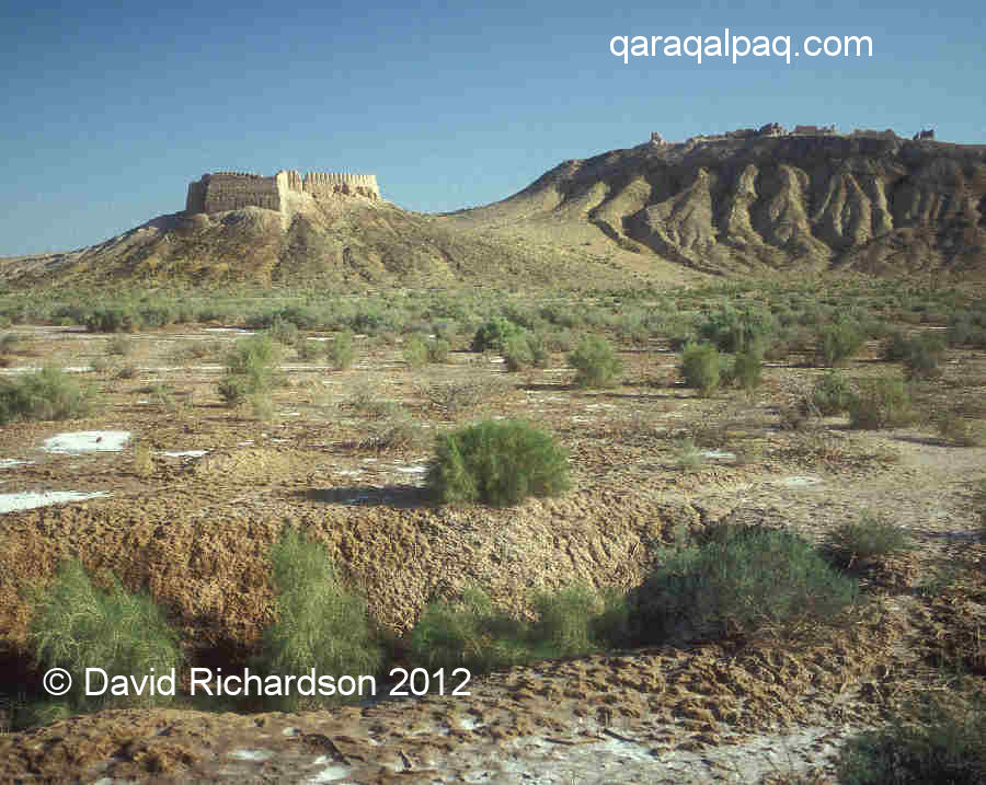
The 6th to 8th century medieval fort of Ayaz qala 2 overlooked by
the much older 4th and 3rd century hill-top fort of Ayaz qala 1 on the right.
Ayaz qala is located in a desert region of Ellikqala tuman on the eastern side of the Sultan Uvays Dag mountains. In the first millennium BC
this was an oasis watered by the southern part of the Akcha Darya river. Ayaz qala Lake, which was once part of the Akcha Darya river bed, lies to
the north of the Ayaz qala site. It is a good spot for swimming and birdwatching and supports a nesting site for terns during the summer.
Excavations
There are three Ayaz qala monuments:
- Ayaz qala 1, a defensive refuge dating from the 4th or early 3rd century BC, located on the top of a flat hill,
- Ayaz qala 2, a feudal fort probably dating from the 6th to the 8th century AD, and
- Ayaz qala 3, a fortified garrison and refuge, mainly dating from the 1st to 2nd centuries AD.
The three sites of Ayaz qala: top Ayaz qala 1, middle Ayaz qala 2, and bottom Ayaz qala 3.
Image courtesy of Google Earth.
All three were surveyed in 1937 during the early days of the Khorezm Archaeological Expedition and excavations were carried out at Ayaz qala 3 in 1939.
Ayaz qala 1 was investigated in more detail by Yuri Manilov in the late 1960's.
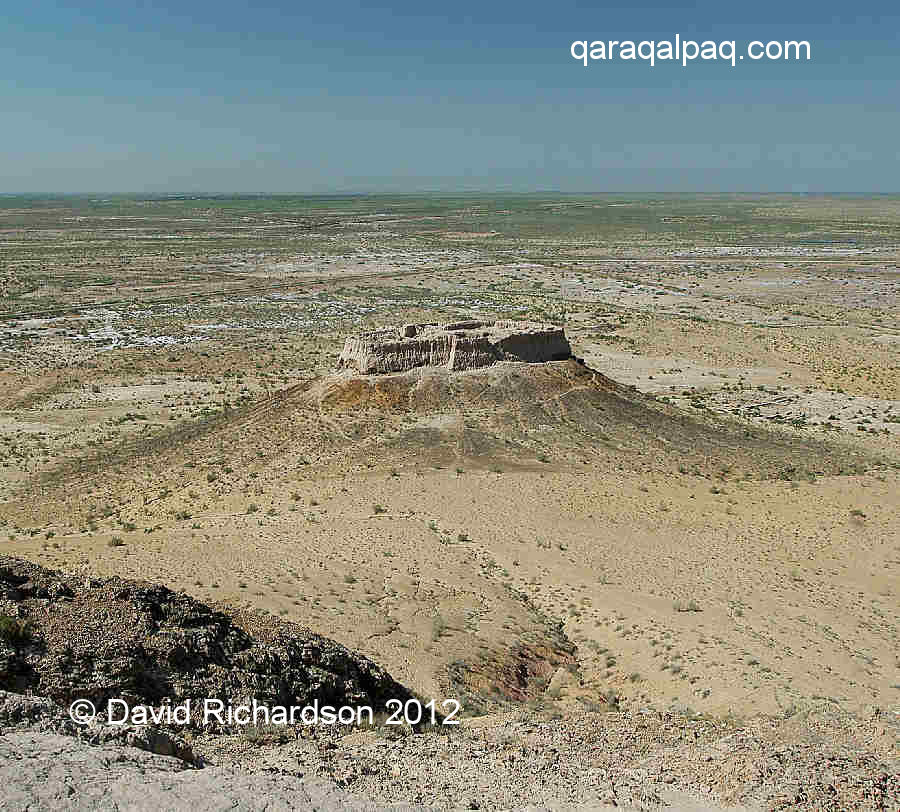
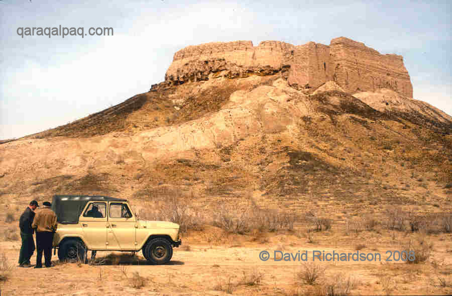
Ayaz qala 1
Ayaz qala 1 is a fortified refuge that was probably built in the 4th century BC just after Khorezm had gained its independence from Persia. It was
one of a chain of fortresses defending the main agricultural settlements of the right bank from possible attack by nomads. The neighbouring forts of
Qırq Qız qala can be seen from its battlements. It is likely that the rulers of Khorezm attempted to maintain friendly relationships
with the local tribes and to engage them in trade, thus creating a political buffer zone around the oasis. However there may have been threats from
further afield, such as from the warlike Saka roaming along the banks of the lower Syr Darya. Throughout history powerful nomads have shown a
propensity to raid rather than trade with their more wealthy settled neighbours.
Satellite image of Ayaz qala 1. Image courtesy of Google Earth.
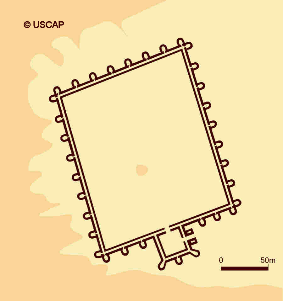
Schematic plan of Ayaz qala 1.
Image courtesy of Associate Professor Alison Betts, University of Sydney Central Asian Programme.
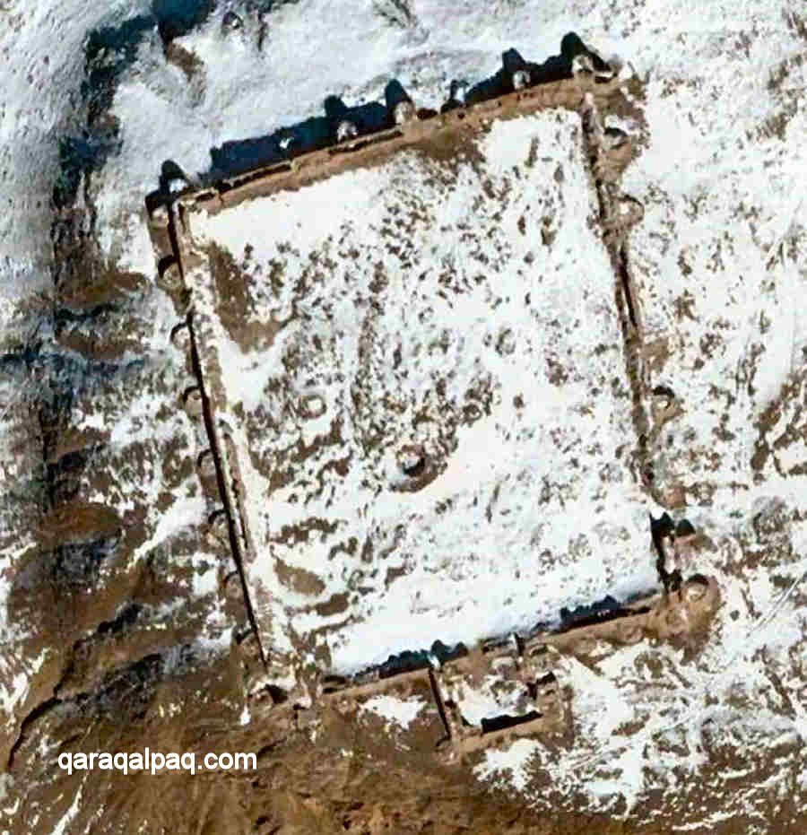
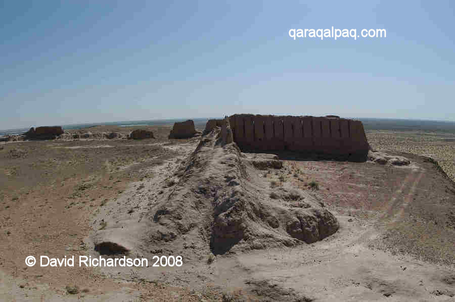
The fort is rectangular in layout and extends for about 180m by 150m over the flat top of a limestone hill, which despite its low elevation still
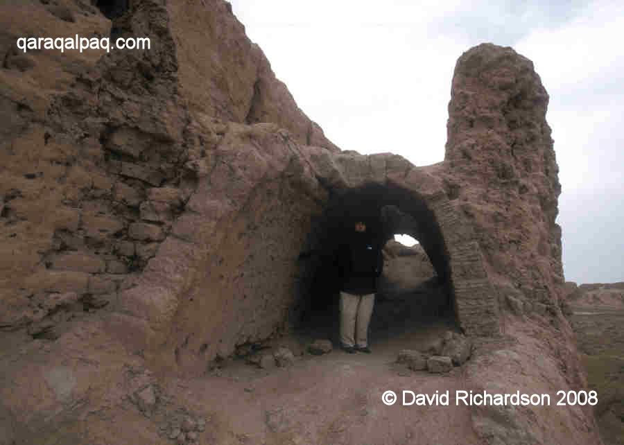
provides extensive views over the surrounding plains. The refuge is enclosed by two parallel walls, separated by about two metres. They had a maximum
height of 10m. The inner and outer walls had a vaulted corridor running between � some of which can still be seen - supporting an upper rampart. Arrow
slits in the outer wall provided archers with good views of potential attackers.
Sue standing by the vaulted corridor between the inner and outer walls of Ayaz qala 1 on a freezing March day in 2002.
The outer walls were reinforced during the 3rd century BC by the addition of 45 regularly spaced semi-elliptical watch towers, the towers on the
eastern and western sides being shorter than those on the northern side. We know they are additions because they were not bonded into the outer wall.
The western flank of Ayaz qala 1 showing the crumbling semi-elliptical watch towers.
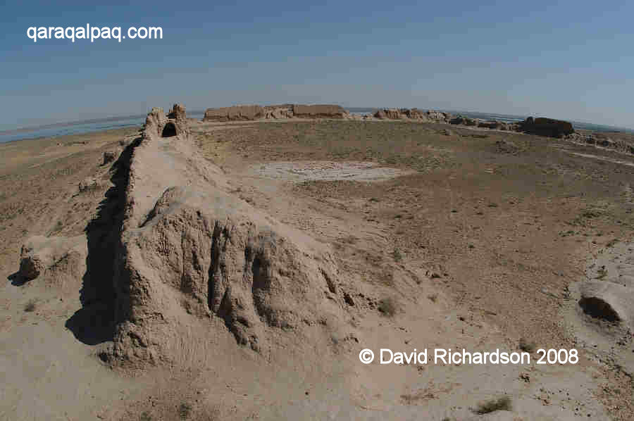
Access to the fort was gained by means of a labyrinth entrance, located on the southern flank of the fort. Visitors approached the fort along this
flank, overlooked by defenders. They first passed through a massive gateway supported by two projecting rectangular towers and entered a small
rectangular holding chamber, where they could be inspected while being covered by surrounding archers. Once accepted they were forced to turn right
to enter the gate of the main refuge. The inside of the fort was completely devoid of permanent buildings although there may have been a central
cistern for storing rain water.
Panoramic view of the empty interior refuge of Ayaz qala 1.
Note the vaulted arch and the Akcha Ko'l Lake in the background.
The rectangular entrance on the southern flank of Ayaz qala 1.
The fortress is thought to have continued in use up to around the 1st century AD, although it might have provided refuge for local inhabitants well
into the early medieval period.
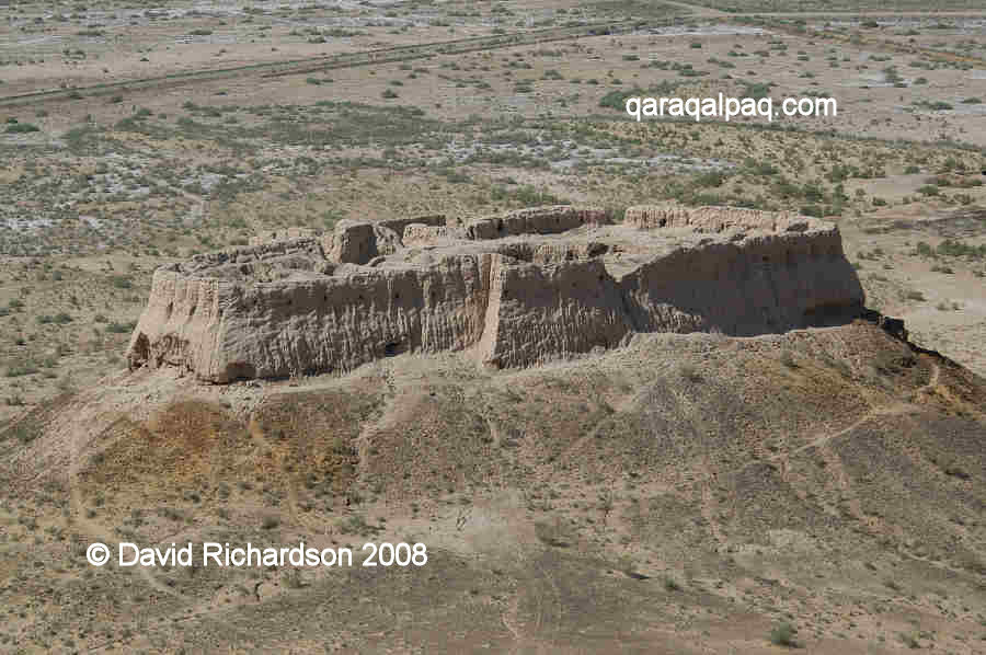
Ayaz qala 2
Ayaz qala 2 is a much smaller feudal fort built on a conical hill to the south west of Ayaz qala 1. It has an irregular shape with a rounded end on
the eastern side and a rectangular end on the western side. There is an additional rectangular entrance structure on its southern side and a long ramp
leading down to a complex of ruins below.
The early medieval feudal fort of Ayaz qala 2 as seen from the edge of Ayaz qala 1.
The site is best viewed from the top of Ayaz qala 1.
Satellite image of Ayaz qala 2. Image courtesy of Google Earth.
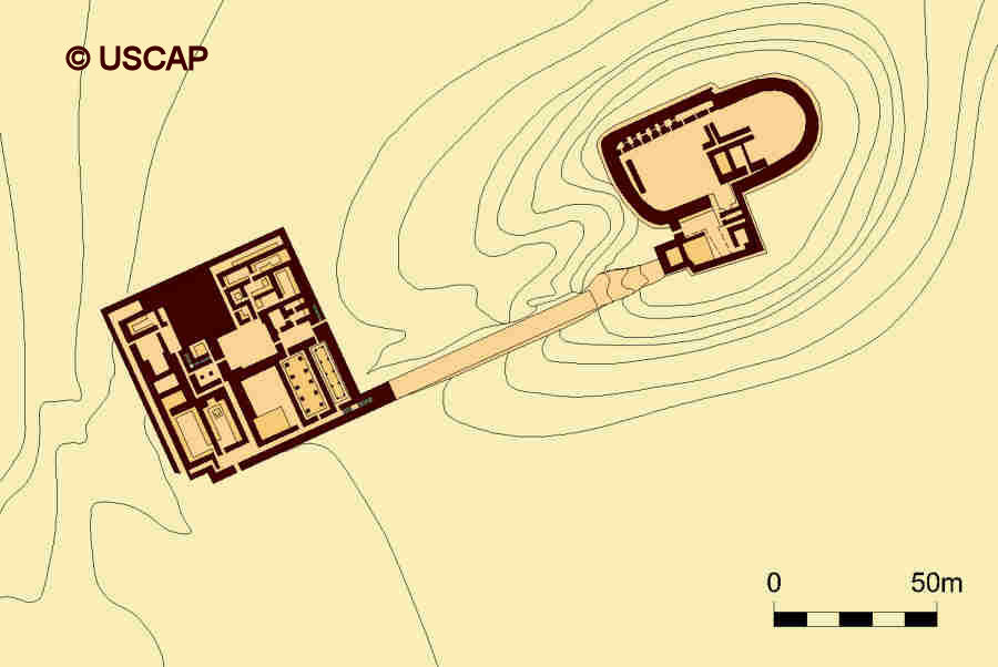
Schematic plan of Ayaz qala 2.
Image courtesy of Associate Professor Alison Betts, University of Sydney Central Asian Programme.
In the absence of any serious excavations, archaeologists suspect that the fort was built at some time between the 6th to the 8th centuries AD, a period
when Khorezm was ruled by the Afrigid dynasty of Khorezmshahs. As Khorezm had expanded and grown prosperous, a new class of feudal landowners had
emerged. They were the offspring of the ancient nobility, senior courtiers, or those who had been rewarded for loyal military service. They were
known as dihqans and their agricultural estates were called rustaq. Most lived in small square-shaped forts (called donjons)
surrounded by a defensive wall, generally located at the head of the canal that watered their agricultural lands. From there they ruled over their
individual fiefdoms, composed of the families of feudal serfs who worked and managed their lands and the craftsmen who produced their necessities.
Most of these feudal donjons have disappeared during the past seventy years as a result of widescale agricultural development, but an important
example known as Yakke Parsan still stands only 10km due south of Ayaz qala.
|
Looking up at Ayaz qala 2 from the south west.
Note the rectangular entrance and the long sloping staircase.
View of Ayaz qala 2 from the battlements of Ayaz qala 1.
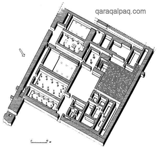
In this respect the architecture of Ayaz qala 2 is quite unique. It was built of rectangular mud bricks on a foundation of compacted clay known as
paqsa. The upper parts of the outer walls appear to have been crenulated. The building was fortified with low battlements and a single row
of arrow slits running around the entire perimeter. The almost square entrance chamber is on a lower level than the main fort, the latter containing a
number of rooms including one with a vaulted ceiling at the north eastern end.
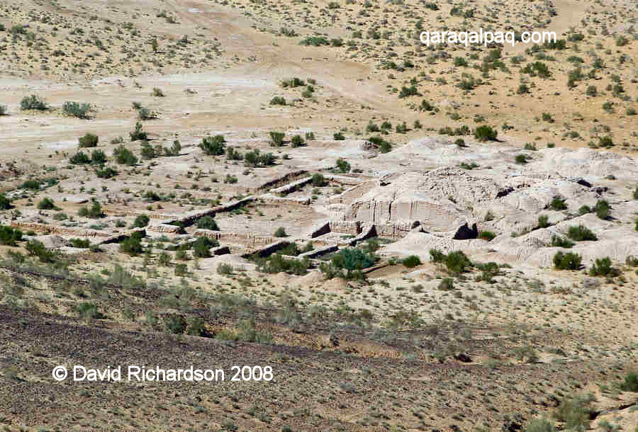
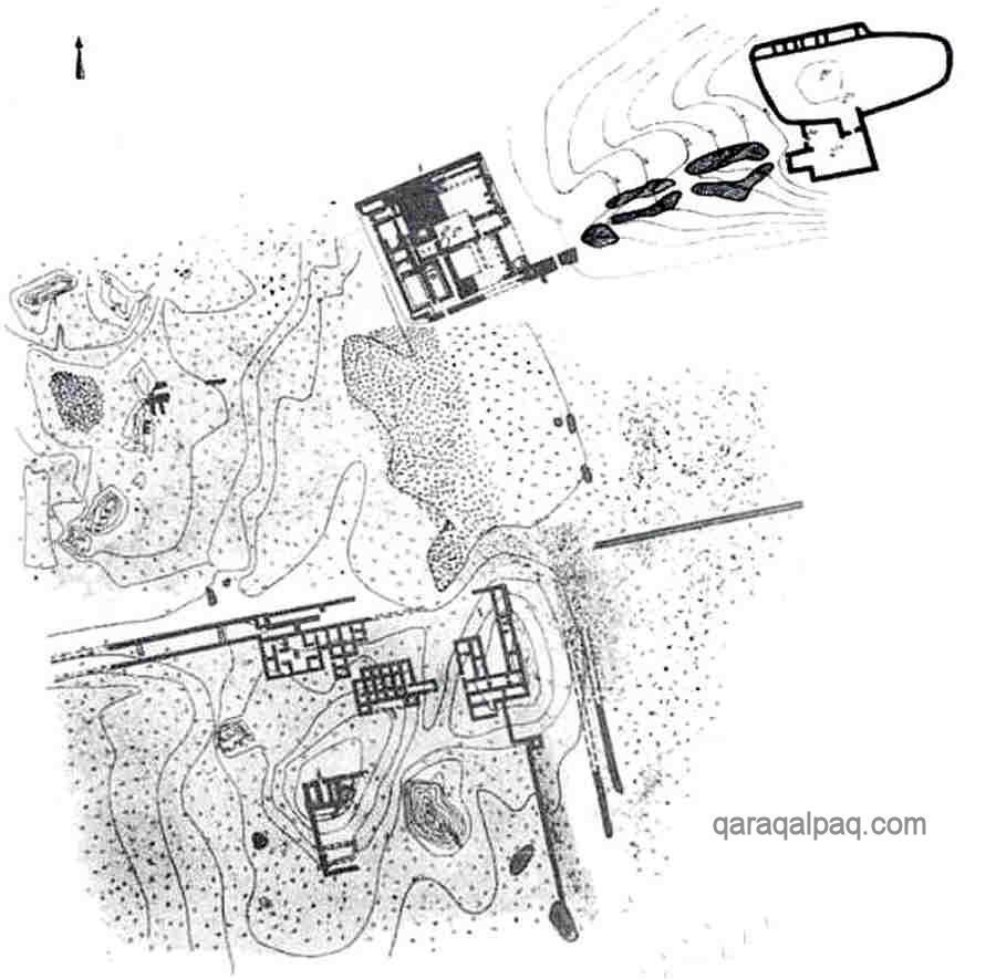
Ruins of the excavations of the palace below Ayaz qala 2, showing its complex arrangement.
Another unusual feature is the 50 metre-long sloping man-made staircase that rises up to the entrance of the fort on the southern side. At the foot
of the ramp are the remains of a large square building, which is thought to have been a palace. It contained residential quarters along with numerous
ceremonial halls with ceilings supported by multiple columns, one of which seems to have been a fire temple. It was lavishly decorated with wall
paintings and must have been the residence of an important and wealthy feudal lord, loyal to the Khorezmian throne.
Reconstruction of the palace showing the numerous hyperstyle halls.
From Nerazik, E. E., "In the Lower Reaches of the Oxus and Jaksartes", page 71, Moscow, 2000.
The palace was built in the 4th century AD but was destroyed at a later date by two separate fires. Given the palace's location one wonders if there
was an associated defensive building on the conical hill predating Ayaz qala 2. The palace seems to have been re-used as a domestic dwelling during
the 6th to 7th centuries, possibly by the same feudal family who built the fortress.
The remains of a residential area just south of the ruins of the palace at Ayaz qala 2.
From Nerazik, E. E., and Bulgakov, P. G., History and Culture of Khwarizm, History of the Civilizations of Central Asia, Volume 3, UNESCO, 1996.
It also seems that Ayaz qala 2 stood in the centre of a small rural agricultural community since there are traces of many residential buildings surrounding
the foot of the conical hill on which it sits. It is possible that Ayaz qala 2 continued to be used up until the Mongol invasion in the early 13th century.
Ayaz qala 2 was used as a backdrop for a Central Asian movie about Chinggis Khan. Amazingly the film crew were permitted to repair some of the walls
and to rebuild the entry gate prior to filming.
Ayaz qala 1 and 2 are best photographed at sunset.
Ayaz qala 3
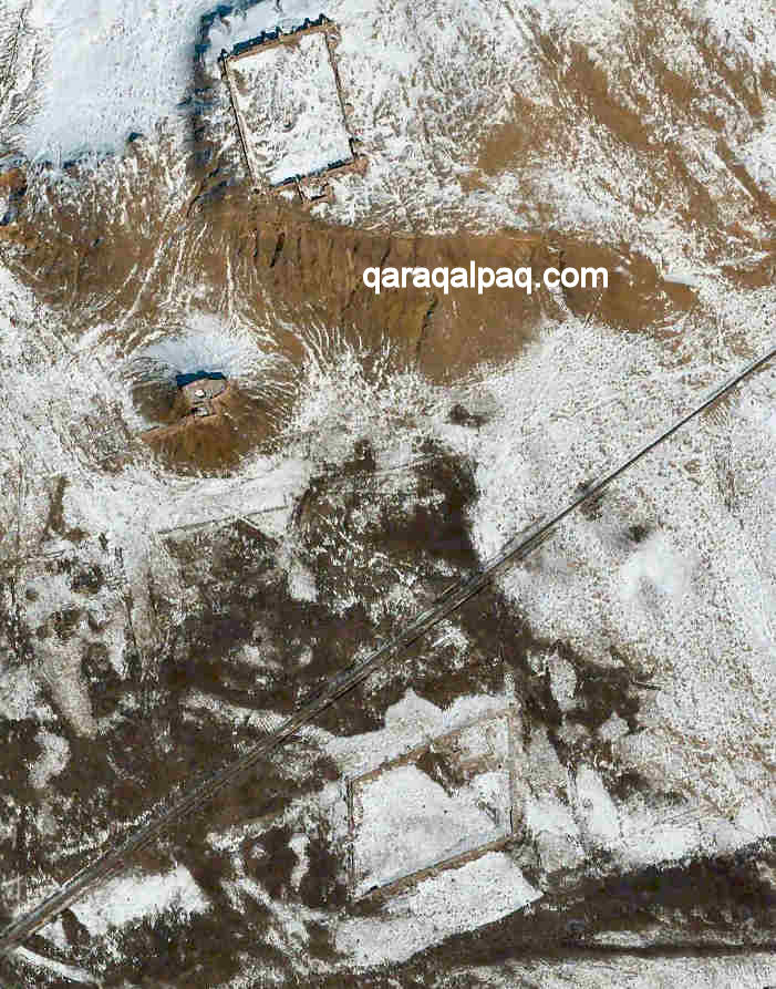
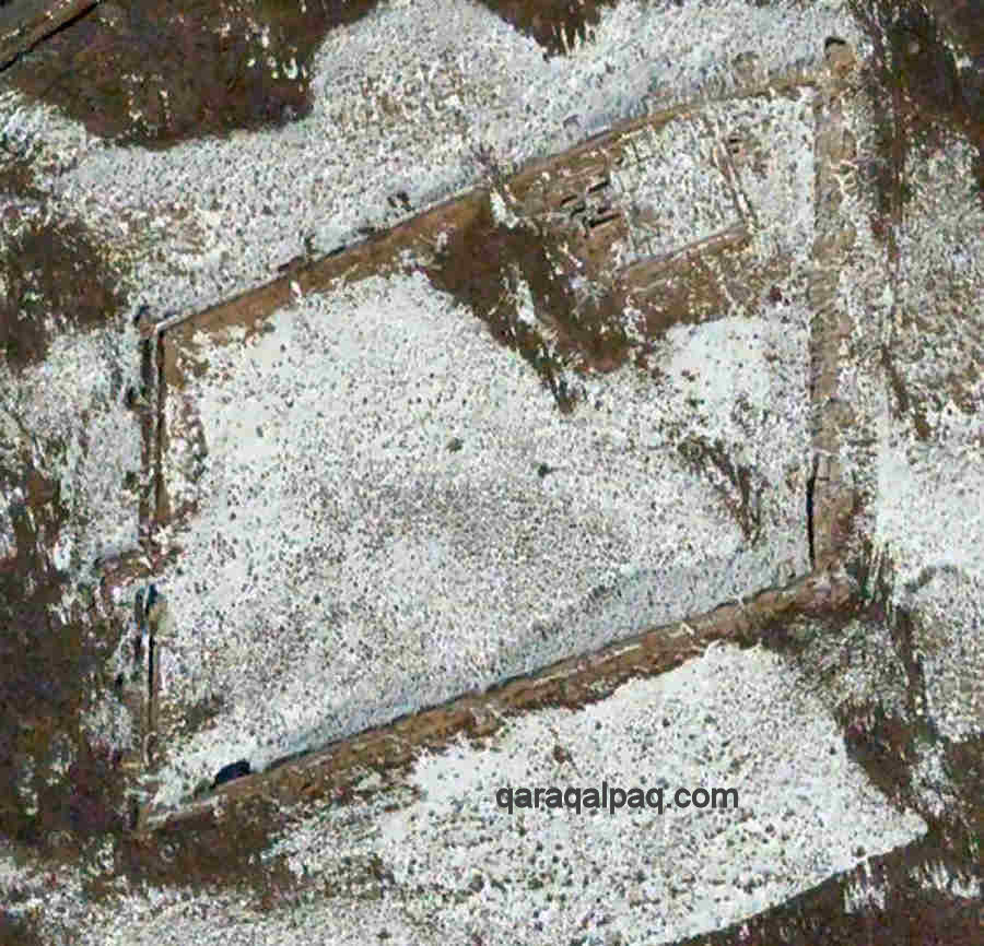
Ayaz qala 3 is a large fortified garrison built in the shape of a parallelogram and located on the desert plain one kilometre due south of Ayaz qala 1.
Covering an area of 260 by 190 metres it is about 66% larger than Ayaz qala 1 and as such is one of the larger fortresses in Qaraqalpaqstan.
However it is still dwarfed by Axsha-Xan qala, which is almost three times larger. It has square towers at each corner and rectangular towers
defending each flank. The entrance was in the middle of the western wall and was defended by a barbican with galleried walls and a flanking tower.
Satellite image of Ayaz qala 3. Image courtesy of Google Earth.
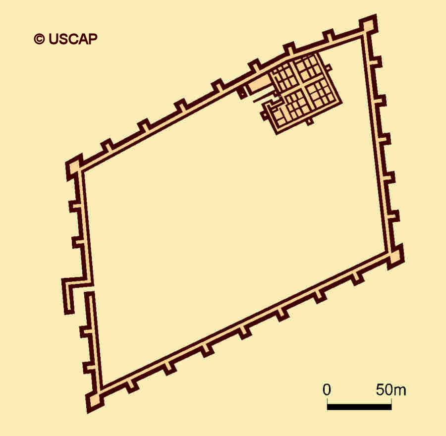
Schematic plan of Ayaz qala 3.
Image courtesy of Associate Professor Alison Betts, University of Sydney Central Asian Programme.
Much of the interior was empty apart from a rectangular fortified building set against the northern wall in the north east corner. The building
contained 40 small rooms divided into four groups by two cross-shaped central corridors. Additional corridors run around the sides of three of the
outer walls.
The enclosure is surrounded by the remains of many farmsteads and the boundaries of fields.
Excavations conducted in 1939 concluded that the whole site dated from the 1st to the 2nd centuries AD - the time of the Kushan Empire. Interestingly
several other skew-shaped Kushan buildings are known from this time. However more recent work suggests that the fortified building within the
perimeter wall is earlier, dating from the 5th to 4th centuries BC, almost contemporary with Ayaz qala 1. When the later parallelogram-shaped enclosure
was constructed the earlier fortified building was incorporated into the perimeter wall, creating a kink in the construction.
It seems that Ayaz qala 3 may have been a more convenient garrison than Ayaz Qala 1 during the Kushan period, offering a closer refuge for the local
agricultural population. However Ayaz qala 1 may have still been manned as a lookout post. The earlier monumental building may have been the residence
of a local ruler or senior military commander.
The Legend of Ayaz Khan
The origin of the name Ayaz remains uncertain.
According to Sergey Tolstov, the name Ayaz comes from a Qazaq legend about the origin of Khorezm and the Aral Sea. A long time ago the lands below
the current Aral Sea were occupied by two tribes, the Adagy ruled by Fasyl Khan and the Baysyn ruled by Ayaz Khan. Ayaz Khan had once been a slave but
thanks to his wisdom and justice he had eventually become the leader of his people. The Amu Darya and Syr Darya at that time flowed into the Caspian
Sea. But when Fasyl Khan dishonoured the daughter of a religious mullah, the course of the rivers changed and as a punishment flooded the lands and
towns of the Adagy below the surface of the Aral Sea. To escape the flood, Ayaz Khan and his people moved south and so founded the kingdom of Khorezm.
Links
Those interested in the conservation and architectural details of the Ayaz Qala sites will find the following report on a recent restoration project
particularly useful: http://unesdoc.unesco.org/images/0014/001482/148218m.pdf.
Google Earth Coordinates
The following reference point (in degrees and digital minutes) will enable you to locate Ayaz qala on Google Earth:
| | Google Earth Coordinates |
|---|
| Place | Latitude North | Longitude East |
|---|
| Ayaz qala 1 | 42º 0.854 | 61º 1.746 |
| Ayaz qala 2 | 42º 0.654 | 61º 1.630 |
| Ayaz qala 3 | 42º 0.320 | 61º 1.830 |
| | | |
Note that these are not GPS measurements taken on the ground.
Return to top of page
Home Page
|